Dārāb geodata
Dārāb (Fars) is a seat of a second-order administrative division; located in Iran in Asia/Tehran (GMT+3.5) time zone. With population of 63,319 people, there are 102 cities with bigger population in this country. Compared to other cities in Iran, 89.8% of cities are located further ↑North; 75.5% of cities are located further ←West and 52.6% of cities have higher elevation than Dārāb. Note1


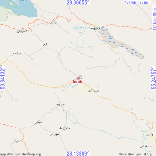
Dārāb GPS coordinates[2]
28° 45' 6.984" North, 54° 32' 39.984" East
| Map corner | latitude | longitude |
|---|---|---|
| Upper-left | 29.36655°, | 53.84132° |
| Center: | 28.75194°, | 54.54444° |
| Lower-right: | 28.13369°, | 55.24757° |
| Map W x H: | 137.1×137.1 km | = 85.2×85.2mi |
| max Lat: | 39.6482° ⇑89.8% North |
| Dārāb: | 28.75194° |
| min Lat: | ⇓10.2% South 25.2919° |
| min Long | Dārāb | max Long |
| 44.38416° | 54.54444° | 61.9965° |
| W 75.5%⇐ | ⇒24.5% E |
Elevation
Elevation of Dārāb is 1131 m = 3711 ft, and this is 82 m = 269 ft above average elevation for this country.
| Max E: |
2564 m = 8412 ft | 52.6% |
| Dārāb | 1131 m 3711 ft | |
| Avg. | 1049 m = 3442 ft | |
Min E: |
-24 m = -79 ft | 47.4% |
See also: Dārāb elevation on elevation.city.
Geographical zone
Dārāb is located in North temperate zone (between Tropic of Cancer and the Arctic Circle). Distance of this Northern Tropic circle is 591 km =367.2 mi to South.| Distance of | km | miles | from Dārāb |
|---|---|---|---|
| North Pole | 6810.1 | 4231.6 | to North |
| Arctic Circle | 4204.3 | 2612.4 | to North |
| Tropic Cancer | 591 | 367.2 | to South |
| Equator | 3196.9 | 1986.5 | to South |


Nearby cities:
15 places around Dārāb: (largest is in red/bold)
• Estahbān
64.2 km =39.9 mi,  310°
310°
• Fasā
89.7 km =55.7 mi,  283°
283°
• Gerāsh
126.8 km =78.8 mi,  198°
198°
• Jahrom
100 km =62.1 mi,  253°
253°
• Kherāmeh
145.7 km =90.5 mi,  304°
304°
• Khonj
144.8 km =90 mi,  228°
228°
• Neyrīz
54 km =33.6 mi,  337°
337°
• Qīr
150.4 km =93.5 mi,  258°
258°
• Sarvestān
141.2 km =87.7 mi,  294°
294°
• Shahr-e Bābak
161.6 km =100.4 mi,  20°
20°
• Shahr-e Herāt
145.7 km =90.5 mi,  353°
353°
• Shahr-e Qadīm-e Lār
120.5 km =74.9 mi,  189°
189°
• Sirjan
135 km =83.9 mi,  54°
54°
• Ḩājjīābād
45.4 km =28.2 mi, 195°
• Ḩājjīābād
141.4 km =87.9 mi,  110°
110°
Sources, notices
• [Note1] Compared only with cities in Iran existing in our database
• [Src1] Map data: © OpenStreetMap contributors (CC-BY-SA)
• [Src2] Other city data from geonames.org with taken over terms of usage.
• [Src3] Geographical zone / Annual Mean Temperature by Robert A. Rohde @ Wikipedia
