Shahr-e Qadīm-e Lār geodata
Shahr-e Qadīm-e Lār (Fars) is a seat of a second-order administrative division; located in Iran in Asia/Tehran (GMT+3.5) time zone. In our database, there are 232 cities with bigger population. Compared to other cities in Iran, 93.9% of cities are located further ↑North; 73.5% of cities are located further ←West and 66% of cities have higher elevation than Shahr-e Qadīm-e Lār. Note1


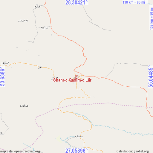
Shahr-e Qadīm-e Lār GPS coordinates[2]
27° 41' 0.096" North, 54° 20' 30.192" East
| Map corner | latitude | longitude |
|---|---|---|
| Upper-left | 28.30421°, | 53.6386° |
| Center: | 27.68336°, | 54.34172° |
| Lower-right: | 27.05896°, | 55.04485° |
| Map W x H: | 138.5×138.5 km | = 86.1×86.1mi |
| max Lat: | 39.6482° ⇑93.9% North |
| Shahr-e Qadīm-e Lār: | 27.68336° |
| min Lat: | ⇓6.1% South 25.2919° |
| min Long | Shahr-e Qadīm- | max Long |
| 44.38416° | 54.34172° | 61.9965° |
| W 73.5%⇐ | ⇒26.5% E |
Elevation
Elevation of Shahr-e Qadīm-e Lār is 818 m = 2684 ft, and this is 231 m = 758 ft below average elevation for this country.
| Max E: |
2564 m = 8412 ft | 66% |
| Avg. | 1049 m = 3442 ft | |
| Shahr-e Qadīm-e Lār | 818 m = 2684 ft | |
Min E: |
-24 m = -79 ft | 34% |
See also: Iran elevation on elevation.city.
Geographical zone
Shahr-e Qadīm-e Lār is located in North temperate zone (between Tropic of Cancer and the Arctic Circle). Distance of this Northern Tropic circle is 472.2 km =293.4 mi to South.| Distance of | km | miles | from Shahr-e Qadīm-e Lār |
|---|---|---|---|
| North Pole | 6929 | 4305.5 | to North |
| Arctic Circle | 4323.1 | 2686.2 | to North |
| Tropic Cancer | 472.2 | 293.4 | to South |
| Equator | 3078.1 | 1912.6 | to South |


Nearby cities:
15 places around Shahr-e Qadīm-e Lār: (largest is in red/bold)
• Bandar-e Khamīr
147.3 km =91.5 mi,  123°
123°
• Bandar-e Lengeh
136 km =84.5 mi,  156°
156°
• Bastak
53.9 km =33.5 mi,  177°
177°
• Dārāb
120.5 km =74.9 mi,  9°
9°
• Estahbān
163.1 km =101.3 mi,  349°
349°
• Fasā
155.2 km =96.4 mi,  334°
334°
• Gerāsh
20.3 km =12.6 mi,  265°
265°
• Gāvbandī
139.2 km =86.5 mi,  247°
247°
• Jahrom
118.8 km =73.8 mi,  319°
319°
• Khonj
92.2 km =57.3 mi,  284°
284°
• Kīsh
129.2 km =80.3 mi,  194°
194°
• Lamerd
121.1 km =75.2 mi, 251°
• Mohr
144.4 km =89.7 mi,  264°
264°
• Qīr
156 km =96.9 mi,  304°
304°
• Ḩājjīābād
75.4 km =46.9 mi, 6°
Sources, notices
• [Note1] Compared only with cities in Iran existing in our database
• [Src1] Map data: © OpenStreetMap contributors (CC-BY-SA)
• [Src2] Other city data from geonames.org with taken over terms of usage.
• [Src3] Geographical zone / Annual Mean Temperature by Robert A. Rohde @ Wikipedia
