Gerāsh geodata
Gerāsh (Fars) is a seat of a second-order administrative division; located in Iran in Asia/Tehran (GMT+3.5) time zone. With population of 25,316 people, there are 184 cities with bigger population in this country. Compared to other cities in Iran, 94.1% of cities are located further ↑North; 72.6% of cities are located further ←West and 62.6% of cities have higher elevation than Gerāsh. Note1


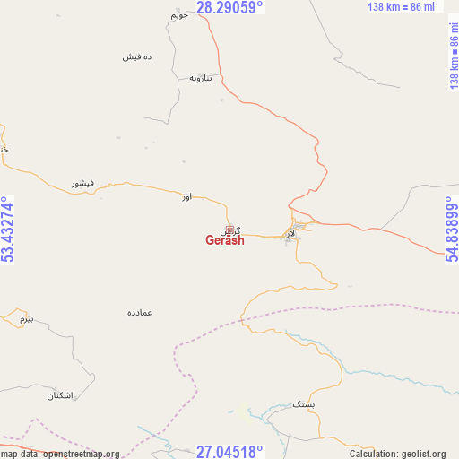
Gerāsh GPS coordinates[2]
27° 40' 10.776" North, 54° 8' 9.096" East
| Map corner | latitude | longitude |
|---|---|---|
| Upper-left | 28.29059°, | 53.43274° |
| Center: | 27.66966°, | 54.13586° |
| Lower-right: | 27.04518°, | 54.83899° |
| Map W x H: | 138.5×138.5 km | = 86.1×86.1mi |
| max Lat: | 39.6482° ⇑94.1% North |
| Gerāsh: | 27.66966° |
| min Lat: | ⇓5.9% South 25.2919° |
| min Long | Gerāsh | max Long |
| 44.38416° | 54.13586° | 61.9965° |
| W 72.6%⇐ | ⇒27.4% E |
Elevation
Elevation of Gerāsh is 923 m = 3028 ft, and this is 126 m = 413 ft below average elevation for this country.
| Max E: |
2564 m = 8412 ft | 62.6% |
| Avg. | 1049 m = 3442 ft | |
| Gerāsh | 923 m = 3028 ft | |
Min E: |
-24 m = -79 ft | 37.4% |
See also: Iran elevation on elevation.city.
Geographical zone
Gerāsh is located in North temperate zone (between Tropic of Cancer and the Arctic Circle). Distance of this Northern Tropic circle is 470.7 km =292.5 mi to South.| Distance of | km | miles | from Gerāsh |
|---|---|---|---|
| North Pole | 6930.5 | 4306.4 | to North |
| Arctic Circle | 4324.6 | 2687.2 | to North |
| Tropic Cancer | 470.7 | 292.5 | to South |
| Equator | 3076.6 | 1911.7 | to South |


Nearby cities:
15 places around Gerāsh: (largest is in red/bold)
• Bandar-e Lengeh
143.9 km =89.4 mi,  149°
149°
• Bandar-e ‘Asalūyeh
152.2 km =94.6 mi,  261°
261°
• Bastak
57.1 km =35.5 mi,  156°
156°
• Dārāb
126.8 km =78.8 mi,  18°
18°
• Estahbān
162.3 km =100.8 mi,  356°
356°
• Fasā
148.9 km =92.5 mi,  341°
341°
• Gāvbandī
120 km =74.6 mi,  244°
244°
• Jahrom
108.2 km =67.2 mi,  328°
328°
• Khonj
73.3 km =45.5 mi,  289°
289°
• Kīsh
124.2 km =77.2 mi,  185°
185°
• Lamerd
101.5 km =63.1 mi,  248°
248°
• Mohr
124 km =77.1 mi, 264°
• Qīr
140.9 km =87.6 mi,  309°
309°
• Shahr-e Qadīm-e Lār
20.3 km =12.6 mi,  85°
85°
• Ḩājjīābād
81.5 km =50.6 mi, 20°
Sources, notices
• [Note1] Compared only with cities in Iran existing in our database
• [Src1] Map data: © OpenStreetMap contributors (CC-BY-SA)
• [Src2] Other city data from geonames.org with taken over terms of usage.
• [Src3] Geographical zone / Annual Mean Temperature by Robert A. Rohde @ Wikipedia
