Bardsīr geodata
Bardsīr (Kerman) is a seat of a second-order administrative division; located in Iran in Asia/Tehran (GMT+3.5) time zone. With population of 37,192 people, there are 162 cities with bigger population in this country. Compared to other cities in Iran, 83.4% of cities are located further ↑North; 82.3% of cities are located further ←West and 95% of cities have lower elevation than Bardsīr. Note1


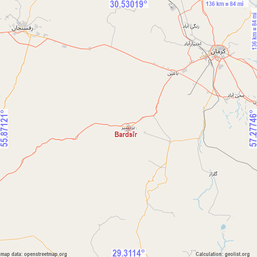
Bardsīr GPS coordinates[2]
29° 55' 21.576" North, 56° 34' 27.588" East
| Map corner | latitude | longitude |
|---|---|---|
| Upper-left | 30.53019°, | 55.87121° |
| Center: | 29.92266°, | 56.57433° |
| Lower-right: | 29.3114°, | 57.27746° |
| Map W x H: | 135.5×135.5 km | = 84.2×84.2mi |
| max Lat: | 39.6482° ⇑83.4% North |
| Bardsīr: | 29.92266° |
| min Lat: | ⇓16.6% South 25.2919° |
| min Long | Bardsīr | max Long |
| 44.38416° | 56.57433° | 61.9965° |
| W 82.3%⇐ | ⇒17.7% E |
Elevation
Elevation of Bardsīr is 2049 m = 6722 ft, and this is 1000 m = 3281 ft above average elevation for this country.
| Max E: |
2564 m = 8412 ft | 5% |
| Bardsīr | 2049 m 6722 ft | |
| Avg. | 1049 m = 3442 ft | |
Min E: |
-24 m = -79 ft | 95% |
See also: Iran elevation on elevation.city.
Geographical zone
Bardsīr is located in North temperate zone (between Tropic of Cancer and the Arctic Circle). Distance of this Northern Tropic circle is 721.2 km =448.1 mi to South.| Distance of | km | miles | from Bardsīr |
|---|---|---|---|
| North Pole | 6680 | 4150.8 | to North |
| Arctic Circle | 4074.1 | 2531.5 | to North |
| Tropic Cancer | 721.2 | 448.1 | to South |
| Equator | 3327.1 | 2067.4 | to South |


Nearby cities:
15 places around Bardsīr: (largest is in red/bold)
• Anār
163.6 km =101.7 mi,  310°
310°
• Arzū’īyeh
165.9 km =103.1 mi,  186°
186°
• Bāft
76.7 km =47.7 mi,  177°
177°
• Jīroft
178.7 km =111 mi,  140°
140°
• Kerman
62.9 km =39.1 mi,  50°
50°
• Kūh Sefīd
75.2 km =46.7 mi,  163°
163°
• Kūhbanān
167.7 km =104.2 mi,  350°
350°
• Rafsanjān
77.5 km =48.2 mi, 313°
• Rābor
77.5 km =48.2 mi,  154°
154°
• Rāvar
151 km =93.8 mi,  8°
8°
• Shahr-e Bābak
141.8 km =88.1 mi,  278°
278°
• Shahrak-e Pābedānā
135.8 km =84.4 mi, 352°
• Sirjan
101 km =62.8 mi,  238°
238°
• Zarand
99 km =61.5 mi,  359°
359°
• Ḩājjīābād
190.9 km =118.6 mi,  200°
200°
Sources, notices
• [Note1] Compared only with cities in Iran existing in our database
• [Src1] Map data: © OpenStreetMap contributors (CC-BY-SA)
• [Src2] Other city data from geonames.org with taken over terms of usage.
• [Src3] Geographical zone / Annual Mean Temperature by Robert A. Rohde @ Wikipedia
