Kerman geodata
Kerman is a seat of a first-order administrative division; located in Iran in Asia/Tehran (GMT+3.5) time zone. With population of 577,514 people, there are 12 cities with bigger population in this country. Compared to other cities in Iran, 81.2% of cities are located further ↑North; 84.1% of cities are located further ←West and 84.1% of cities have lower elevation than Kerman. Note1


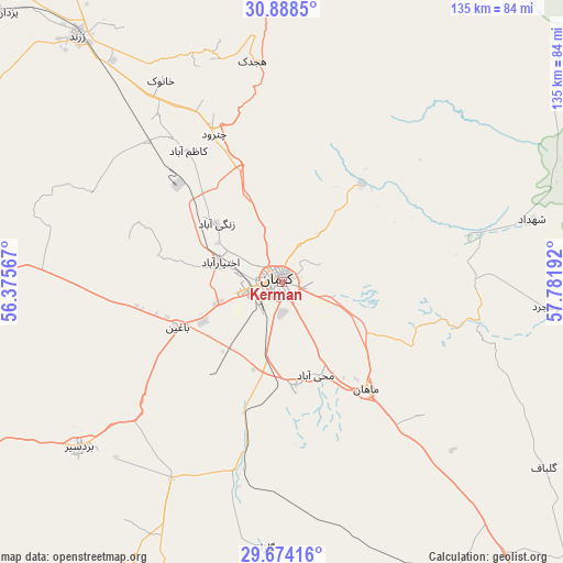
Kerman GPS coordinates[2]
30° 16' 59.556" North, 57° 4' 43.644" East
| Map corner | latitude | longitude |
|---|---|---|
| Upper-left | 30.8885°, | 56.37567° |
| Center: | 30.28321°, | 57.07879° |
| Lower-right: | 29.67416°, | 57.78192° |
| Map W x H: | 135×135 km | = 83.9×83.9mi |
| max Lat: | 39.6482° ⇑81.2% North |
| Kerman: | 30.28321° |
| min Lat: | ⇓18.8% South 25.2919° |
| min Long | Kerman | max Long |
| 44.38416° | 57.07879° | 61.9965° |
| W 84.1%⇐ | ⇒15.9% E |
Elevation
Elevation of Kerman is 1760 m = 5774 ft, and this is 711 m = 2333 ft above average elevation for this country.
| Max E: |
2564 m = 8412 ft | 15.9% |
| Kerman | 1760 m 5774 ft | |
| Avg. | 1049 m = 3442 ft | |
Min E: |
-24 m = -79 ft | 84.1% |
See also: Kerman elevation on elevation.city.
Geographical zone
Kerman is located in North temperate zone (between Tropic of Cancer and the Arctic Circle). Distance of this Northern Tropic circle is 761.3 km =473 mi to South.| Distance of | km | miles | from Kerman |
|---|---|---|---|
| North Pole | 6639.9 | 4125.8 | to North |
| Arctic Circle | 4034 | 2506.6 | to North |
| Tropic Cancer | 761.3 | 473 | to South |
| Equator | 3367.2 | 2092.3 | to South |


Nearby cities:
15 places around Kerman: (largest is in red/bold)
• Anār
185 km =115 mi,  290°
290°
• Bahābād
203.1 km =126.2 mi,  330°
330°
• Bam
179.9 km =111.8 mi,  136°
136°
• Bardsīr
62.9 km =39.1 mi,  230°
230°
• Bāft
125.5 km =78 mi,  201°
201°
• Jīroft
189.6 km =117.8 mi,  160°
160°
• Kūh Sefīd
115.1 km =71.5 mi,  193°
193°
• Kūhbanān
146.6 km =91.1 mi, 328°
• Rafsanjān
105 km =65.2 mi,  277°
277°
• Rābor
111.5 km =69.3 mi, 188°
• Rāvar
112.3 km =69.8 mi,  346°
346°
• Shahr-e Bābak
189.3 km =117.6 mi,  264°
264°
• Shahrak-e Pābedānā
114.9 km =71.4 mi, 325°
• Sirjan
163.5 km =101.6 mi,  235°
235°
• Zarand
76.8 km =47.7 mi,  320°
320°
Sources, notices
• [Note1] Compared only with cities in Iran existing in our database
• [Src1] Map data: © OpenStreetMap contributors (CC-BY-SA)
• [Src2] Other city data from geonames.org with taken over terms of usage.
• [Src3] Geographical zone / Annual Mean Temperature by Robert A. Rohde @ Wikipedia
