Rafsanjān geodata
Rafsanjān (Kerman) is a seat of a second-order administrative division; located in Iran in Asia/Tehran (GMT+3.5) time zone. With population of 147,680 people, there are 50 cities with bigger population in this country. Compared to other cities in Iran, 80.3% of cities are located further ↑North; 80% of cities are located further ←West and 70.7% of cities have lower elevation than Rafsanjān. Note1


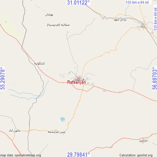
Rafsanjān GPS coordinates[2]
30° 24' 24.12" North, 55° 59' 38.04" East
| Map corner | latitude | longitude |
|---|---|---|
| Upper-left | 31.01122°, | 55.29078° |
| Center: | 30.4067°, | 55.9939° |
| Lower-right: | 29.79841°, | 56.69703° |
| Map W x H: | 134.9×134.9 km | = 83.8×83.8mi |
| max Lat: | 39.6482° ⇑80.3% North |
| Rafsanjān: | 30.4067° |
| min Lat: | ⇓19.7% South 25.2919° |
| min Long | Rafsanjān | max Long |
| 44.38416° | 55.9939° | 61.9965° |
| W 80%⇐ | ⇒20% E |
Elevation
Elevation of Rafsanjān is 1514 m = 4967 ft, and this is 465 m = 1526 ft above average elevation for this country.
| Max E: |
2564 m = 8412 ft | 29.3% |
| Rafsanjān | 1514 m 4967 ft | |
| Avg. | 1049 m = 3442 ft | |
Min E: |
-24 m = -79 ft | 70.7% |
See also: Rafsanjān elevation on elevation.city.
Geographical zone
Rafsanjān is located in North temperate zone (between Tropic of Cancer and the Arctic Circle). Distance of this Northern Tropic circle is 775 km =481.6 mi to South.| Distance of | km | miles | from Rafsanjān |
|---|---|---|---|
| North Pole | 6626.2 | 4117.3 | to North |
| Arctic Circle | 4020.3 | 2498.1 | to North |
| Tropic Cancer | 775 | 481.6 | to South |
| Equator | 3380.9 | 2100.8 | to South |


Nearby cities:
15 places around Rafsanjān: (largest is in red/bold)
• Anār
86.3 km =53.6 mi,  306°
306°
• Bahābād
162.8 km =101.2 mi,  1°
1°
• Bardsīr
77.5 km =48.2 mi,  133°
133°
• Bāfq
144.5 km =89.8 mi,  337°
337°
• Bāft
143.1 km =88.9 mi,  155°
155°
• Kerman
105 km =65.2 mi,  97°
97°
• Kūh Sefīd
147.9 km =91.9 mi,  148°
148°
• Kūhbanān
114.9 km =71.4 mi,  13°
13°
• Rābor
152.5 km =94.8 mi,  144°
144°
• Rāvar
123 km =76.4 mi,  39°
39°
• Shahr-e Bābak
90 km =55.9 mi,  249°
249°
• Shahr-e Herāt
160.6 km =99.8 mi,  255°
255°
• Shahrak-e Pābedānā
89.7 km =55.7 mi,  25°
25°
• Sirjan
110.4 km =68.6 mi,  195°
195°
• Zarand
70.8 km =44 mi,  50°
50°
Sources, notices
• [Note1] Compared only with cities in Iran existing in our database
• [Src1] Map data: © OpenStreetMap contributors (CC-BY-SA)
• [Src2] Other city data from geonames.org with taken over terms of usage.
• [Src3] Geographical zone / Annual Mean Temperature by Robert A. Rohde @ Wikipedia
