Bāft geodata
Bāft (Kerman) is a seat of a second-order administrative division; located in Iran in Asia/Tehran (GMT+3.5) time zone. In our database, there are 232 cities with bigger population. Compared to other cities in Iran, 87.1% of cities are located further ↑North; 82.5% of cities are located further ←West and 98.4% of cities have lower elevation than Bāft. Note1


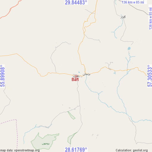
Bāft GPS coordinates[2]
29° 13' 59.16" North, 56° 36' 7.92" East
| Map corner | latitude | longitude |
|---|---|---|
| Upper-left | 29.84483°, | 55.89908° |
| Center: | 29.2331°, | 56.6022° |
| Lower-right: | 28.61769°, | 57.30533° |
| Map W x H: | 136.4×136.4 km | = 84.8×84.8mi |
| max Lat: | 39.6482° ⇑87.1% North |
| Bāft: | 29.2331° |
| min Lat: | ⇓12.9% South 25.2919° |
| min Long | Bāft | max Long |
| 44.38416° | 56.6022° | 61.9965° |
| W 82.5%⇐ | ⇒17.5% E |
Elevation
Elevation of Bāft is 2268 m = 7441 ft, and this is 1219 m = 3999 ft above average elevation for this country.
| Max E: |
2564 m = 8412 ft | 1.6% |
| Bāft | 2268 m 7441 ft | |
| Avg. | 1049 m = 3442 ft | |
Min E: |
-24 m = -79 ft | 98.4% |
See also: Iran elevation on elevation.city.
Geographical zone
Bāft is located in North temperate zone (between Tropic of Cancer and the Arctic Circle). Distance of this Northern Tropic circle is 644.5 km =400.5 mi to South.| Distance of | km | miles | from Bāft |
|---|---|---|---|
| North Pole | 6756.6 | 4198.4 | to North |
| Arctic Circle | 4150.8 | 2579.2 | to North |
| Tropic Cancer | 644.5 | 400.5 | to South |
| Equator | 3250.4 | 2019.7 | to South |


Nearby cities:
15 places around Bāft: (largest is in red/bold)
• Arzū’īyeh
90.8 km =56.4 mi,  194°
194°
• Bam
171 km =106.3 mi,  94°
94°
• Bardsīr
76.7 km =47.7 mi,  357°
357°
• Fāryāb
140.3 km =87.2 mi,  154°
154°
• Jīroft
126.8 km =78.8 mi,  119°
119°
• Kahnūj
178.2 km =110.7 mi,  143°
143°
• Kerman
125.5 km =78 mi,  21°
21°
• Kūh Sefīd
19.9 km =12.4 mi,  76°
76°
• Rafsanjān
143.1 km =88.9 mi,  335°
335°
• Rābor
30.8 km =19.1 mi, 77°
• Shahr-e Bābak
173.8 km =108 mi,  304°
304°
• Sirjan
92.5 km =57.5 mi,  285°
285°
• Zarand
175.7 km =109.2 mi, 358°
• Ḩājjīābād
123.4 km =76.7 mi,  213°
213°
• ‘Anbarābād
147.7 km =91.8 mi, 124°
Sources, notices
• [Note1] Compared only with cities in Iran existing in our database
• [Src1] Map data: © OpenStreetMap contributors (CC-BY-SA)
• [Src2] Other city data from geonames.org with taken over terms of usage.
• [Src3] Geographical zone / Annual Mean Temperature by Robert A. Rohde @ Wikipedia
