Marsabit geodata
Marsabit is a seat of a first-order administrative division; located in Kenya in Africa/Nairobi (GMT+3) time zone. With population of 15,361 people, there are 48 cities with bigger population in this country. Compared to other cities in Kenya, 97.4% of cities are located further ↓South; 78.9% of cities are located further ←West and 55.3% of cities have higher elevation than Marsabit. Note1


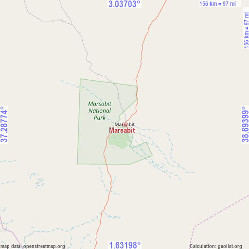
Marsabit GPS coordinates[2]
2° 20' 4.848" North, 37° 59' 27.096" East
| Map corner | latitude | longitude |
|---|---|---|
| Upper-left | 3.03703°, | 37.28774° |
| Center: | 2.33468°, | 37.99086° |
| Lower-right: | 1.63198°, | 38.69399° |
| Map W x H: | 156.2×156.2 km | = 97.1×97.1mi |
| max Lat: | 3.93726° ⇑2.6% North |
| Marsabit: | 2.33468° |
| min Lat: | ⇓97.4% South -4.64756° |
| min Long | Marsabit | max Long |
| 33.97248° | 37.99086° | 41.85688° |
| W 78.9%⇐ | ⇒21.1% E |
Elevation
Elevation of Marsabit is 1364 m = 4475 ft, and this is 17.3 m = 57 ft above average elevation for this country.
| Max E: |
2514 m = 8248 ft | 55.3% |
| Marsabit | 1364 m 4475 ft | |
| Avg. | 1346.7 m = 4418 ft | |
Min E: |
7 m = 23 ft | 44.7% |
See also: Kenya elevation on elevation.city.
Geographical zone
Marsabit is located in North Torrid zone (between Equator and Tropic of Cancer). Distance of Equator is 259.6 km =161.3 mi to South.| Distance of | km | miles | from Marsabit |
|---|---|---|---|
| North Pole | 9747.5 | 6056.8 | to North |
| Arctic Circle | 7141.6 | 4437.6 | to North |
| Tropic Cancer | 2346.3 | 1457.9 | to North |
| Equator | 259.6 | 161.3 | to South |


Nearby cities:
15 places around Marsabit: (largest is in red/bold)
• Baringo
306.2 km =190.3 mi,  227°
227°
• Chuka
299.1 km =185.9 mi,  187°
187°
• Isiolo
224.8 km =139.7 mi, 191°
• Kapsowar
309.5 km =192.3 mi,  240°
240°
• Kathwana
296.8 km =184.4 mi,  182°
182°
• Lodwar
279.9 km =173.9 mi,  288°
288°
• Maralal
199 km =123.7 mi, 226°
• Maua
233.7 km =145.2 mi, 181°
• Meru
257.2 km =159.8 mi, 188°
• Moyale
177.6 km =110.4 mi,  41°
41°
• Nanyuki
278.2 km =172.9 mi,  201°
201°
• Naro Moru
298.1 km =185.2 mi, 201°
• Nyahururu
312.9 km =194.4 mi,  215°
215°
• Rumuruti
280.5 km =174.3 mi, 215°
• Wajir
238.7 km =148.3 mi,  105°
105°
Sources, notices
• [Note1] Compared only with cities in Kenya existing in our database
• [Src1] Map data: © OpenStreetMap contributors (CC-BY-SA)
• [Src2] Other city data from geonames.org with taken over terms of usage.
• [Src3] Geographical zone / Annual Mean Temperature by Robert A. Rohde @ Wikipedia
