Naryn geodata
Naryn is a seat of a first-order administrative division; located in Kyrgyzstan in Asia/Bishkek (GMT+6) time zone. With population of 52,300 people, there are 6 cities with bigger population in this country. Compared to other cities in Kyrgyzstan, 60.7% of cities are located further ↓South; 89.3% of cities are located further ←West and 96.4% of cities have lower elevation than Naryn. Note1


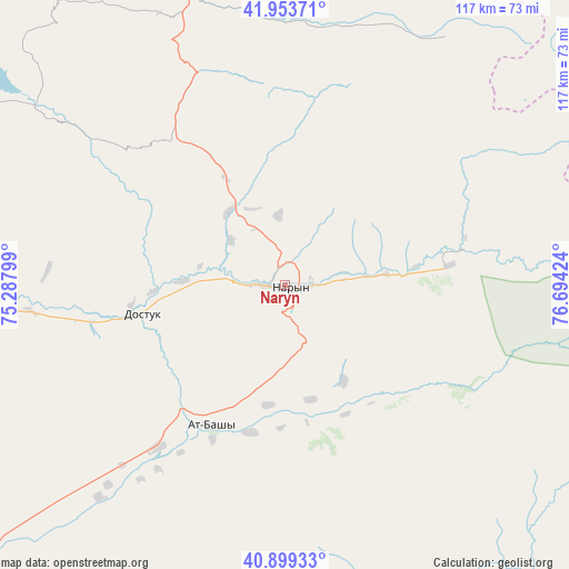
Naryn GPS coordinates[2]
41° 25' 43.176" North, 75° 59' 27.996" East
| Map corner | latitude | longitude |
|---|---|---|
| Upper-left | 41.95371°, | 75.28799° |
| Center: | 41.42866°, | 75.99111° |
| Lower-right: | 40.89933°, | 76.69424° |
| Map W x H: | 117.2×117.2 km | = 72.8×72.8mi |
| max Lat: | 42.89106° ⇑39.3% North |
| Naryn: | 41.42866° |
| min Lat: | ⇓60.7% South 39.55274° |
| min Long | Naryn | max Long |
| 69.3716° | 75.99111° | 78.52702° |
| W 89.3%⇐ | ⇒10.7% E |
Elevation
Elevation of Naryn is 2048 m = 6719 ft, and this is 846.6 m = 2778 ft above average elevation for this country.
| Max E: |
2638 m = 8655 ft | 3.6% |
| Naryn | 2048 m 6719 ft | |
| Avg. | 1201.4 m = 3942 ft | |
Min E: |
504 m = 1654 ft | 96.4% |
See also: Naryn elevation on elevation.city.
Geographical zone
Naryn is located in North temperate zone (between Tropic of Cancer and the Arctic Circle). Distance of this Northern Tropic circle is 2000.5 km =1243.1 mi to South.| Distance of | km | miles | from Naryn |
|---|---|---|---|
| North Pole | 5400.6 | 3355.8 | to North |
| Arctic Circle | 2794.7 | 1736.5 | to North |
| Tropic Cancer | 2000.5 | 1243.1 | to South |
| Equator | 4606.4 | 2862.3 | to South |


Nearby cities:
15 places around Naryn: (largest is in red/bold)
• At-Bashi
32.9 km =20.4 mi,  208°
208°
• Baetovo
88.2 km =54.8 mi,  258°
258°
• Balykchy
115.8 km =72 mi,  8°
8°
• Bokombayevskoye
113 km =70.2 mi,  47°
47°
• Chayek
134.4 km =83.5 mi,  294°
294°
• Cholpon-Ata
162.9 km =101.2 mi,  33°
33°
• Chuy
165.3 km =102.7 mi,  339°
339°
• Ivanovka
178.6 km =111 mi, 335°
• Kadzhi-Say
126.4 km =78.5 mi, 51°
• Kant
187.8 km =116.7 mi,  329°
329°
• Kazarman
163.7 km =101.7 mi,  269°
269°
• Kemin
152.9 km =95 mi,  350°
350°
• Kochkor
89.6 km =55.7 mi, 347°
• Tokmok
167.1 km =103.8 mi, 340°
• Tossor
145.6 km =90.5 mi,  55°
55°
Sources, notices
• [Note1] Compared only with cities in Kyrgyzstan existing in our database
• [Src1] Map data: © OpenStreetMap contributors (CC-BY-SA)
• [Src2] Other city data from geonames.org with taken over terms of usage.
• [Src3] Geographical zone / Annual Mean Temperature by Robert A. Rohde @ Wikipedia
