Bokombayevskoye geodata
Bokombayevskoye (Issyk-Kul) is a seat of a second-order administrative division; located in Kyrgyzstan in Asia/Bishkek (GMT+6) time zone. In our database, there are 37 cities with bigger population. Compared to other cities in Kyrgyzstan, 67.9% of cities are located further ↓South; 91.7% of cities are located further ←West and 90.5% of cities have lower elevation than Bokombayevskoye. Note1


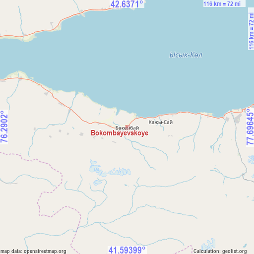
Bokombayevskoye GPS coordinates[2]
42° 7' 3.684" North, 76° 59' 35.952" East
| Map corner | latitude | longitude |
|---|---|---|
| Upper-left | 42.6371°, | 76.2902° |
| Center: | 42.11769°, | 76.99332° |
| Lower-right: | 41.59399°, | 77.69645° |
| Map W x H: | 116×116 km | = 72.1×72.1mi |
| max Lat: | 42.89106° ⇑32.1% North |
| Bokombayevskoye: | 42.11769° |
| min Lat: | ⇓67.9% South 39.55274° |
| min Long | Bokombayevskoye | max Long |
| 69.3716° | 76.99332° | 78.52702° |
| W 91.7%⇐ | ⇒8.3% E |
Elevation
Elevation of Bokombayevskoye is 1810 m = 5938 ft, and this is 608.6 m = 1997 ft above average elevation for this country.
| Max E: |
2638 m = 8655 ft | 9.5% |
| Bokombayevskoye | 1810 m 5938 ft | |
| Avg. | 1201.4 m = 3942 ft | |
Min E: |
504 m = 1654 ft | 90.5% |
See also: Kyrgyzstan elevation on elevation.city.
Geographical zone
Bokombayevskoye is located in North temperate zone (between Tropic of Cancer and the Arctic Circle). Distance of this Northern Tropic circle is 2077.1 km =1290.6 mi to South.| Distance of | km | miles | from Bokombayevskoye |
|---|---|---|---|
| North Pole | 5324 | 3308.2 | to North |
| Arctic Circle | 2718.1 | 1688.9 | to North |
| Tropic Cancer | 2077.1 | 1290.6 | to South |
| Equator | 4683 | 2909.9 | to South |


Nearby cities:
15 places around Bokombayevskoye: (largest is in red/bold)
• Ak-Suu
133.1 km =82.7 mi,  71°
71°
• At-Bashi
144.7 km =89.9 mi,  223°
223°
• Balykchy
76.5 km =47.5 mi,  299°
299°
• Cholpon-Ata
59.6 km =37 mi,  7°
7°
• Chuy
160.6 km =99.8 mi, 299°
• Ivanovka
178.3 km =110.8 mi, 298°
• Kadzhi-Say
15.5 km =9.6 mi,  80°
80°
• Karakol
122.4 km =76.1 mi, 70°
• Kemin
130.1 km =80.8 mi, 304°
• Kochkor
102.5 km =63.7 mi,  276°
276°
• Kyzyl-Suu
87.1 km =54.1 mi, 73°
• Naryn
113 km =70.2 mi,  227°
227°
• Tokmok
160.4 km =99.7 mi, 300°
• Tossor
37.3 km =23.2 mi, 81°
• Tyup
131.4 km =81.6 mi,  58°
58°
Sources, notices
• [Note1] Compared only with cities in Kyrgyzstan existing in our database
• [Src1] Map data: © OpenStreetMap contributors (CC-BY-SA)
• [Src2] Other city data from geonames.org with taken over terms of usage.
• [Src3] Geographical zone / Annual Mean Temperature by Robert A. Rohde @ Wikipedia
