Baetovo geodata
Baetovo (Naryn) is a seat of a second-order administrative division; located in Kyrgyzstan in Asia/Bishkek (GMT+6) time zone. In our database, there are 37 cities with bigger population. Compared to other cities in Kyrgyzstan, 56% of cities are located further ↓South; 81% of cities are located further ←West and 94% of cities have lower elevation than Baetovo. Note1


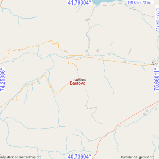
Baetovo GPS coordinates[2]
41° 16' 0.048" North, 74° 57' 25.128" East
| Map corner | latitude | longitude |
|---|---|---|
| Upper-left | 41.79304°, | 74.25386° |
| Center: | 41.26668°, | 74.95698° |
| Lower-right: | 40.73604°, | 75.66011° |
| Map W x H: | 117.5×117.5 km | = 73×73mi |
| max Lat: | 42.89106° ⇑44% North |
| Baetovo: | 41.26668° |
| min Lat: | ⇓56% South 39.55274° |
| min Long | Baetovo | max Long |
| 69.3716° | 74.95698° | 78.52702° |
| W 81%⇐ | ⇒19% E |
Elevation
Elevation of Baetovo is 1951 m = 6401 ft, and this is 749.6 m = 2459 ft above average elevation for this country.
| Max E: |
2638 m = 8655 ft | 6% |
| Baetovo | 1951 m 6401 ft | |
| Avg. | 1201.4 m = 3942 ft | |
Min E: |
504 m = 1654 ft | 94% |
See also: Kyrgyzstan elevation on elevation.city.
Geographical zone
Baetovo is located in North temperate zone (between Tropic of Cancer and the Arctic Circle). Distance of this Northern Tropic circle is 1982.5 km =1231.9 mi to South.| Distance of | km | miles | from Baetovo |
|---|---|---|---|
| North Pole | 5418.6 | 3367 | to North |
| Arctic Circle | 2812.7 | 1747.7 | to North |
| Tropic Cancer | 1982.5 | 1231.9 | to South |
| Equator | 4588.4 | 2851.1 | to South |


Nearby cities:
15 places around Baetovo: (largest is in red/bold)
• At-Bashi
71.4 km =44.4 mi,  98°
98°
• Balykchy
167.3 km =104 mi,  37°
37°
• Chayek
82.1 km =51 mi,  333°
333°
• Chuy
174.8 km =108.6 mi,  8°
8°
• Gul’cha
165.7 km =103 mi,  230°
230°
• Jalal-Abad
168.1 km =104.5 mi,  257°
257°
• Kara-Kulja
134.6 km =83.6 mi,  238°
238°
• Kazarman
79 km =49.1 mi,  281°
281°
• Kochkor
124.6 km =77.4 mi,  32°
32°
• Naryn
88.2 km =54.8 mi,  78°
78°
• Sosnovka
175.8 km =109.2 mi, 330°
• Suzak
176.8 km =109.9 mi, 256°
• Tokmok
177.4 km =110.2 mi, 9°
• Uzgen
149.5 km =92.9 mi,  248°
248°
• Üch-Terek
156.3 km =97.1 mi,  290°
290°
Sources, notices
• [Note1] Compared only with cities in Kyrgyzstan existing in our database
• [Src1] Map data: © OpenStreetMap contributors (CC-BY-SA)
• [Src2] Other city data from geonames.org with taken over terms of usage.
• [Src3] Geographical zone / Annual Mean Temperature by Robert A. Rohde @ Wikipedia
