Shīeli geodata
Shīeli (Qyzylorda) is a populated place; located in Kazakhstan in Asia/Qyzylorda (GMT+5) time zone. With population of 29,832 people, there are 52 cities with bigger population in this country. Compared to other cities in Kazakhstan, 78.9% of cities are located further ↑North; 68.5% of cities are located further →East and 74.4% of cities have higher elevation than Shīeli. Note1


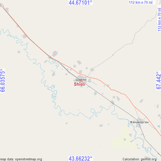
Shīeli GPS coordinates[2]
44° 10' 7.752" North, 66° 44' 19.932" East
| Map corner | latitude | longitude |
|---|---|---|
| Upper-left | 44.67101°, | 66.03575° |
| Center: | 44.16882°, | 66.73887° |
| Lower-right: | 43.66232°, | 67.442° |
| Map W x H: | 112.2×112.2 km | = 69.7×69.7mi |
| max Lat: | 54.90596° ⇑78.9% North |
| Shīeli: | 44.16882° |
| min Lat: | ⇓21.1% South 40.66338° |
| min Long | Shīeli | max Long |
| 46.83361° | 66.73887° | 84.87144° |
| W 31.5%⇐ | ⇒68.5% E |
Elevation
Elevation of Shīeli is 154 m = 505 ft, and this is 202.5 m = 664 ft below average elevation for this country.
| Max E: |
1847 m = 6060 ft | 74.4% |
| Avg. | 356.5 m = 1170 ft | |
| Shīeli | 154 m = 505 ft | |
Min E: |
-26 m = -85 ft | 25.6% |
See also: Kazakhstan elevation on elevation.city.
Geographical zone
Shīeli is located in North temperate zone (between Tropic of Cancer and the Arctic Circle). Distance of this Northern Tropic circle is 2305.2 km =1432.4 mi to South.| Distance of | km | miles | from Shīeli |
|---|---|---|---|
| North Pole | 5095.9 | 3166.4 | to North |
| Arctic Circle | 2490.1 | 1547.3 | to North |
| Tropic Cancer | 2305.2 | 1432.4 | to South |
| Equator | 4911.1 | 3051.6 | to South |


Nearby cities:
15 places around Shīeli: (largest is in red/bold)
• Ashchysay
186.1 km =115.6 mi,  111°
111°
• Belköl
115.9 km =72 mi,  308°
308°
• Chayan
247.3 km =153.7 mi,  120°
120°
• Chulakkurgan
200.3 km =124.5 mi,  102°
102°
• Dzhalagash
192.9 km =119.9 mi,  301°
301°
• Kantagi
164.1 km =102 mi, 115°
• Kentau
159.1 km =98.9 mi, 117°
• Kyzylorda
123.7 km =76.9 mi, 307°
• Qogham
194.2 km =120.7 mi,  140°
140°
• Shalqīya
56.5 km =35.1 mi, 108°
• Tasböget
115.7 km =71.9 mi, 305°
• Terenozek
170 km =105.6 mi, 305°
• Turkestan
155.4 km =96.6 mi,  128°
128°
• Yanykurgan
50 km =31.1 mi, 125°
• Zhangatas
249.4 km =155 mi, 105°
Sources, notices
• [Note1] Compared only with cities in Kazakhstan existing in our database
• [Src1] Map data: © OpenStreetMap contributors (CC-BY-SA)
• [Src2] Other city data from geonames.org with taken over terms of usage.
• [Src3] Geographical zone / Annual Mean Temperature by Robert A. Rohde @ Wikipedia
