Dzhetygara geodata
Dzhetygara (Qostanay) is a populated place; located in Kazakhstan in Asia/Qostanay (GMT+5) time zone. With population of 43,104 people, there are 33 cities with bigger population in this country. Compared to other cities in Kazakhstan, 83.3% of cities are located further ↓South; 80.4% of cities are located further →East and 55.9% of cities have higher elevation than Dzhetygara. Note1


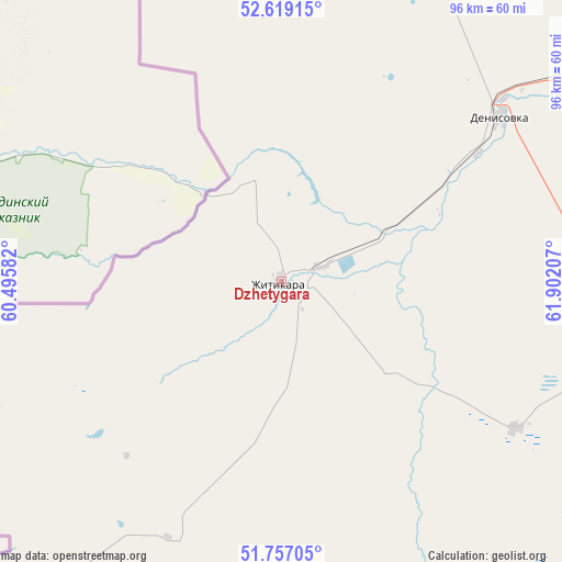
Dzhetygara GPS coordinates[2]
52° 11' 24.684" North, 61° 11' 56.184" East
| Map corner | latitude | longitude |
|---|---|---|
| Upper-left | 52.61915°, | 60.49582° |
| Center: | 52.19019°, | 61.19894° |
| Lower-right: | 51.75705°, | 61.90207° |
| Map W x H: | 95.9×95.9 km | = 59.6×59.6mi |
| max Lat: | 54.90596° ⇑16.7% North |
| Dzhetygara: | 52.19019° |
| min Lat: | ⇓83.3% South 40.66338° |
| min Long | Dzhetygara | max Long |
| 46.83361° | 61.19894° | 84.87144° |
| W 19.6%⇐ | ⇒80.4% E |
Elevation
Elevation of Dzhetygara is 271 m = 889 ft, and this is 85.5 m = 281 ft below average elevation for this country.
| Max E: |
1847 m = 6060 ft | 55.9% |
| Avg. | 356.5 m = 1170 ft | |
| Dzhetygara | 271 m = 889 ft | |
Min E: |
-26 m = -85 ft | 44.1% |
See also: Dzhetygara elevation on elevation.city.
Geographical zone
Dzhetygara is located in North temperate zone (between Tropic of Cancer and the Arctic Circle). Distance of this North polar circle is 1598.2 km =993.1 mi to North.| Distance of | km | miles | from Dzhetygara |
|---|---|---|---|
| North Pole | 4204.1 | 2612.3 | to North |
| Arctic Circle | 1598.2 | 993.1 | to North |
| Tropic Cancer | 3197.1 | 1986.6 | to South |
| Equator | 5803 | 3605.8 | to South |


Nearby cities:
15 places around Dzhetygara: (largest is in red/bold)
• Ayat
114.7 km =71.3 mi,  51°
51°
• Batamshinskiy
271.9 km =169 mi,  228°
228°
• Borovskoy
267.6 km =166.3 mi, 48°
• Fyodorovka
189.7 km =117.9 mi,  31°
31°
• Khromtau
288.7 km =179.4 mi,  221°
221°
• Komsomolets
182.8 km =113.6 mi,  18°
18°
• Kostanay
199.2 km =123.8 mi,  55°
55°
• Lisakovsk
96.8 km =60.1 mi,  65°
65°
• Ordzhonikidze
47.1 km =29.3 mi, 52°
• Qashar
172.5 km =107.2 mi,  40°
40°
• Qusmuryn
234.3 km =145.6 mi,  82°
82°
• Rudnyy
156.1 km =97 mi, 56°
• Tobol
109.7 km =68.2 mi, 59°
• Torghay
326.7 km =203 mi,  150°
150°
• Yrghyz
397.4 km =246.9 mi,  179°
179°
Sources, notices
• [Note1] Compared only with cities in Kazakhstan existing in our database
• [Src1] Map data: © OpenStreetMap contributors (CC-BY-SA)
• [Src2] Other city data from geonames.org with taken over terms of usage.
• [Src3] Geographical zone / Annual Mean Temperature by Robert A. Rohde @ Wikipedia
