Kaztalovka geodata
Kaztalovka (Batys Qazaqstan) is a populated place; located in Kazakhstan in Asia/Oral (GMT+5) time zone. With population of 4,825 people, there are 198 cities with bigger population in this country. Compared to other cities in Kazakhstan, 62.2% of cities are located further ↓South; 99.3% of cities are located further →East and 91.9% of cities have higher elevation than Kaztalovka. Note1


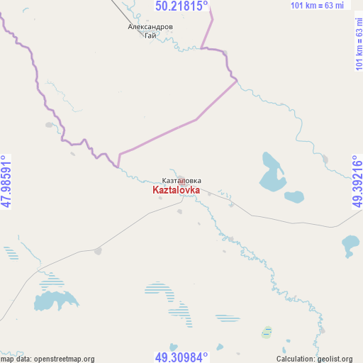
Kaztalovka GPS coordinates[2]
49° 45' 58.032" North, 48° 41' 20.508" East
| Map corner | latitude | longitude |
|---|---|---|
| Upper-left | 50.21815°, | 47.98591° |
| Center: | 49.76612°, | 48.68903° |
| Lower-right: | 49.30984°, | 49.39216° |
| Map W x H: | 101×101 km | = 62.8×62.8mi |
| max Lat: | 54.90596° ⇑37.8% North |
| Kaztalovka: | 49.76612° |
| min Lat: | ⇓62.2% South 40.66338° |
| min Long | Kaztalovka | max Long |
| 46.83361° | 48.68903° | 84.87144° |
| W 0.7%⇐ | ⇒99.3% E |
Elevation
Elevation of Kaztalovka is 14 m = 46 ft, and this is 342.5 m = 1124 ft below average elevation for this country.
| Max E: |
1847 m = 6060 ft | 91.9% |
| Avg. | 356.5 m = 1170 ft | |
| Kaztalovka | 14 m = 46 ft | |
Min E: |
-26 m = -85 ft | 8.1% |
See also: Kazakhstan elevation on elevation.city.
Geographical zone
Kaztalovka is located in North temperate zone (between Tropic of Cancer and the Arctic Circle). Distance of this North polar circle is 1867.7 km =1160.5 mi to North.| Distance of | km | miles | from Kaztalovka |
|---|---|---|---|
| North Pole | 4473.6 | 2779.8 | to North |
| Arctic Circle | 1867.7 | 1160.5 | to North |
| Tropic Cancer | 2927.6 | 1819.1 | to South |
| Equator | 5533.5 | 3438.4 | to South |


Nearby cities:
15 places around Kaztalovka: (largest is in red/bold)
• Chapaev
183.6 km =114.1 mi,  74°
74°
• Dzhambeyty
284.6 km =176.8 mi,  78°
78°
• Dzhangala
133.5 km =83 mi,  117°
117°
• Fedorovka
282.1 km =175.3 mi,  55°
55°
• Inderbor
262.5 km =163.1 mi, 121°
• Krūgloozernoe
235 km =146 mi,  51°
51°
• Makhambet
315.5 km =196 mi,  137°
137°
• Maloye Ganyushkino
354.6 km =220.3 mi,  173°
173°
• Oral
249.9 km =155.3 mi, 49°
• Peremetnoe
221.1 km =137.4 mi,  43°
43°
• Saykhin
168.3 km =104.6 mi,  233°
233°
• Shalkar
193.3 km =120.1 mi,  175°
175°
• Tasqala
187.8 km =116.7 mi, 37°
• Zhumysker
70.3 km =43.7 mi,  133°
133°
• Zhänibek
138.2 km =85.9 mi,  253°
253°
Sources, notices
• [Note1] Compared only with cities in Kazakhstan existing in our database
• [Src1] Map data: © OpenStreetMap contributors (CC-BY-SA)
• [Src2] Other city data from geonames.org with taken over terms of usage.
• [Src3] Geographical zone / Annual Mean Temperature by Robert A. Rohde @ Wikipedia
