Krūgloozernoe geodata
Krūgloozernoe (Batys Qazaqstan) is a populated place; located in Kazakhstan in Asia/Oral (GMT+5) time zone. With population of 2,977 people, there are 228 cities with bigger population in this country. Compared to other cities in Kazakhstan, 74.4% of cities are located further ↓South; 94.8% of cities are located further →East and 91.1% of cities have higher elevation than Krūgloozernoe. Note1


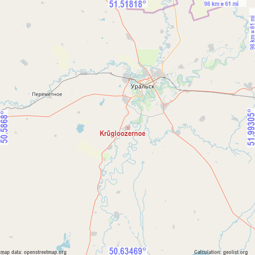
Krūgloozernoe GPS coordinates[2]
51° 4' 42.744" North, 51° 17' 23.712" East
| Map corner | latitude | longitude |
|---|---|---|
| Upper-left | 51.51818°, | 50.5868° |
| Center: | 51.07854°, | 51.28992° |
| Lower-right: | 50.63469°, | 51.99305° |
| Map W x H: | 98.2×98.2 km | = 61×61mi |
| max Lat: | 54.90596° ⇑25.6% North |
| Krūgloozernoe: | 51.07854° |
| min Lat: | ⇓74.4% South 40.66338° |
| min Long | Krūgloozernoe | max Long |
| 46.83361° | 51.28992° | 84.87144° |
| W 5.2%⇐ | ⇒94.8% E |
Elevation
Elevation of Krūgloozernoe is 28 m = 92 ft, and this is 328.5 m = 1078 ft below average elevation for this country.
| Max E: |
1847 m = 6060 ft | 91.1% |
| Avg. | 356.5 m = 1170 ft | |
| Krūgloozernoe | 28 m = 92 ft | |
Min E: |
-26 m = -85 ft | 8.9% |
See also: Kazakhstan elevation on elevation.city.
Geographical zone
Krūgloozernoe is located in North temperate zone (between Tropic of Cancer and the Arctic Circle). Distance of this North polar circle is 1721.8 km =1069.9 mi to North.| Distance of | km | miles | from Krūgloozernoe |
|---|---|---|---|
| North Pole | 4327.7 | 2689.1 | to North |
| Arctic Circle | 1721.8 | 1069.9 | to North |
| Tropic Cancer | 3073.5 | 1909.8 | to South |
| Equator | 5679.4 | 3529 | to South |


Nearby cities:
15 places around Krūgloozernoe: (largest is in red/bold)
• Akkol’
290.2 km =180.3 mi,  152°
152°
• Aqsay
119.6 km =74.3 mi,  85°
85°
• Burlin
106.4 km =66.1 mi,  68°
68°
• Chapaev
98.1 km =61 mi,  185°
185°
• Chingirlau
195.2 km =121.3 mi, 89°
• Dzhambeyty
129.8 km =80.7 mi,  134°
134°
• Dzhangala
217.9 km =135.4 mi,  198°
198°
• Fedorovka
49.2 km =30.6 mi, 71°
• Inderbor
283.4 km =176.1 mi,  172°
172°
• Kaztalovka
235 km =146 mi,  231°
231°
• Miyaly
302.4 km =187.9 mi,  143°
143°
• Oral
18 km =11.2 mi,  17°
17°
• Peremetnoe
33.1 km =20.6 mi,  293°
293°
• Tasqala
69.6 km =43.2 mi,  272°
272°
• Zhumysker
236.1 km =146.7 mi,  214°
214°
Sources, notices
• [Note1] Compared only with cities in Kazakhstan existing in our database
• [Src1] Map data: © OpenStreetMap contributors (CC-BY-SA)
• [Src2] Other city data from geonames.org with taken over terms of usage.
• [Src3] Geographical zone / Annual Mean Temperature by Robert A. Rohde @ Wikipedia
