Shymkent geodata
Shymkent is a seat of a first-order administrative division; located in Kazakhstan in Asia/Almaty (GMT+5) time zone. With population of 414,032 people, there are 2 cities with bigger population in this country. Compared to other cities in Kazakhstan, 97.4% of cities are located further ↑North; 54.8% of cities are located further →East and 76.3% of cities have lower elevation than Shymkent. Note1


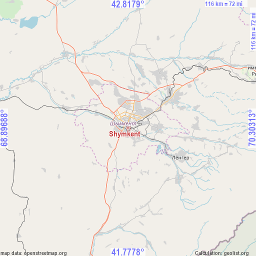
Shymkent GPS coordinates[2]
42° 18' 0" North, 69° 36' 0" East
| Map corner | latitude | longitude |
|---|---|---|
| Upper-left | 42.8179°, | 68.89688° |
| Center: | 42.3°, | 69.6° |
| Lower-right: | 41.7778°, | 70.30313° |
| Map W x H: | 115.6×115.6 km | = 71.8×71.8mi |
| max Lat: | 54.90596° ⇑97.4% North |
| Shymkent: | 42.3° |
| min Lat: | ⇓2.6% South 40.66338° |
| min Long | Shymkent | max Long |
| 46.83361° | 69.6° | 84.87144° |
| W 45.2%⇐ | ⇒54.8% E |
Elevation
Elevation of Shymkent is 513 m = 1683 ft, and this is 156.5 m = 513 ft above average elevation for this country.
| Max E: |
1847 m = 6060 ft | 23.7% |
| Shymkent | 513 m 1683 ft | |
| Avg. | 356.5 m = 1170 ft | |
Min E: |
-26 m = -85 ft | 76.3% |
See also: Shymkent elevation on elevation.city.
Geographical zone
Shymkent is located in North temperate zone (between Tropic of Cancer and the Arctic Circle). Distance of this Northern Tropic circle is 2097.4 km =1303.3 mi to South.| Distance of | km | miles | from Shymkent |
|---|---|---|---|
| North Pole | 5303.7 | 3295.6 | to North |
| Arctic Circle | 2697.9 | 1676.4 | to North |
| Tropic Cancer | 2097.4 | 1303.3 | to South |
| Equator | 4703.3 | 2922.5 | to South |


Nearby cities:
15 places around Shymkent: (largest is in red/bold)
• Arys
66.6 km =41.4 mi,  282°
282°
• Bayzhansay
99.8 km =62 mi,  14°
14°
• Belyye Vody
23.1 km =14.4 mi,  53°
53°
• Chayan
83.6 km =51.9 mi,  347°
347°
• Karatau
120.7 km =75 mi,  35°
35°
• Kokterek
57.9 km =36 mi,  68°
68°
• Lenger
27 km =16.8 mi,  119°
119°
• Leninskoye
63 km =39.1 mi,  196°
196°
• Saryaghash
100 km =62.1 mi, 200°
• Sastobe
43.2 km =26.8 mi, 49°
• Sayram
13 km =8.1 mi,  88°
88°
• Temirlanovka
43.6 km =27.1 mi,  319°
319°
• Turar Ryskulov
66.8 km =41.5 mi, 67°
• Tyul’kubas
60.8 km =37.8 mi, 70°
• Zhabagly
73.8 km =45.9 mi,  78°
78°
In other languages:
- In France: Chymkent
- In German: Schymkent
- In Italian: Şımkent
- In Russian: Шымкент
- In Chinese: 奇姆肯特
Sources, notices
• [Note1] Compared only with cities in Kazakhstan existing in our database
• [Src1] Map data: © OpenStreetMap contributors (CC-BY-SA)
• [Src2] Other city data from geonames.org with taken over terms of usage.
• [Src3] Geographical zone / Annual Mean Temperature by Robert A. Rohde @ Wikipedia
