Sastobe geodata
Sastobe (South Kazakhstan) is a populated place; located in Kazakhstan in Asia/Almaty (GMT+5) time zone. With population of 6,827 people, there are 159 cities with bigger population in this country. Compared to other cities in Kazakhstan, 94.4% of cities are located further ↑North; 51.9% of cities are located further →East and 80.7% of cities have lower elevation than Sastobe. Note1


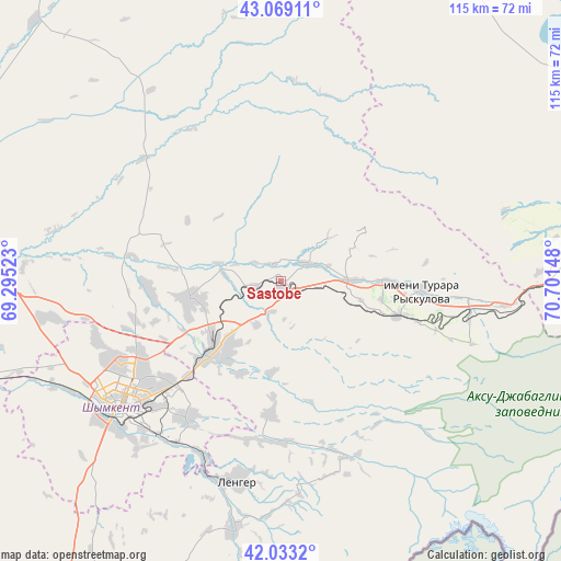
Sastobe GPS coordinates[2]
42° 33' 11.88" North, 69° 59' 54.06" East
| Map corner | latitude | longitude |
|---|---|---|
| Upper-left | 43.06911°, | 69.29523° |
| Center: | 42.5533°, | 69.99835° |
| Lower-right: | 42.0332°, | 70.70148° |
| Map W x H: | 115.2×115.2 km | = 71.6×71.6mi |
| max Lat: | 54.90596° ⇑94.4% North |
| Sastobe: | 42.5533° |
| min Lat: | ⇓5.6% South 40.66338° |
| min Long | Sastobe | max Long |
| 46.83361° | 69.99835° | 84.87144° |
| W 48.1%⇐ | ⇒51.9% E |
Elevation
Elevation of Sastobe is 559 m = 1834 ft, and this is 202.5 m = 664 ft above average elevation for this country.
| Max E: |
1847 m = 6060 ft | 19.3% |
| Sastobe | 559 m 1834 ft | |
| Avg. | 356.5 m = 1170 ft | |
Min E: |
-26 m = -85 ft | 80.7% |
See also: Kazakhstan elevation on elevation.city.
Geographical zone
Sastobe is located in North temperate zone (between Tropic of Cancer and the Arctic Circle). Distance of this Northern Tropic circle is 2125.6 km =1320.8 mi to South.| Distance of | km | miles | from Sastobe |
|---|---|---|---|
| North Pole | 5275.6 | 3278.1 | to North |
| Arctic Circle | 2669.7 | 1658.9 | to North |
| Tropic Cancer | 2125.6 | 1320.8 | to South |
| Equator | 4731.5 | 2940 | to South |


Nearby cities:
15 places around Sastobe: (largest is in red/bold)
• Arys
98.5 km =61.2 mi,  262°
262°
• Bayzhansay
68.6 km =42.6 mi,  354°
354°
• Belyye Vody
20.3 km =12.6 mi,  223°
223°
• Chayan
73.5 km =45.7 mi,  316°
316°
• Karatau
79.4 km =49.3 mi,  28°
28°
• Kokterek
22 km =13.7 mi,  107°
107°
• Lenger
42.4 km =26.3 mi,  192°
192°
• Leninskoye
102.1 km =63.4 mi,  209°
209°
• Sayram
34.2 km =21.3 mi, 215°
• Shymkent
43.2 km =26.8 mi,  229°
229°
• Temirlanovka
60.8 km =37.8 mi,  274°
274°
• Turar Ryskulov
28.9 km =18 mi,  94°
94°
• Tyul’kubas
25.5 km =15.8 mi, 107°
• Zhabagly
41.4 km =25.7 mi, 108°
• Zhangatas
114.2 km =71 mi, 349°
Sources, notices
• [Note1] Compared only with cities in Kazakhstan existing in our database
• [Src1] Map data: © OpenStreetMap contributors (CC-BY-SA)
• [Src2] Other city data from geonames.org with taken over terms of usage.
• [Src3] Geographical zone / Annual Mean Temperature by Robert A. Rohde @ Wikipedia
