Sayram geodata
Sayram (South Kazakhstan) is a seat of a second-order administrative division; located in Kazakhstan in Asia/Almaty (GMT+5) time zone. In our database, there are 268 cities with bigger population. Compared to other cities in Kazakhstan, 97% of cities are located further ↑North; 54.1% of cities are located further →East and 87.4% of cities have lower elevation than Sayram. Note1


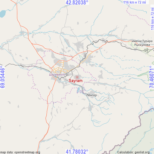
Sayram GPS coordinates[2]
42° 18' 9" North, 69° 45' 27.288" East
| Map corner | latitude | longitude |
|---|---|---|
| Upper-left | 42.82038°, | 69.05446° |
| Center: | 42.3025°, | 69.75758° |
| Lower-right: | 41.78032°, | 70.46071° |
| Map W x H: | 115.6×115.6 km | = 71.8×71.8mi |
| max Lat: | 54.90596° ⇑97% North |
| Sayram: | 42.3025° |
| min Lat: | ⇓3% South 40.66338° |
| min Long | Sayram | max Long |
| 46.83361° | 69.75758° | 84.87144° |
| W 45.9%⇐ | ⇒54.1% E |
Elevation
Elevation of Sayram is 667 m = 2188 ft, and this is 310.5 m = 1019 ft above average elevation for this country.
| Max E: |
1847 m = 6060 ft | 12.6% |
| Sayram | 667 m 2188 ft | |
| Avg. | 356.5 m = 1170 ft | |
Min E: |
-26 m = -85 ft | 87.4% |
See also: Kazakhstan elevation on elevation.city.
Geographical zone
Sayram is located in North temperate zone (between Tropic of Cancer and the Arctic Circle). Distance of this Northern Tropic circle is 2097.7 km =1303.4 mi to South.| Distance of | km | miles | from Sayram |
|---|---|---|---|
| North Pole | 5303.5 | 3295.4 | to North |
| Arctic Circle | 2697.6 | 1676.2 | to North |
| Tropic Cancer | 2097.7 | 1303.4 | to South |
| Equator | 4703.6 | 2922.7 | to South |


Nearby cities:
15 places around Sayram: (largest is in red/bold)
• Arys
79.2 km =49.2 mi,  280°
280°
• Bayzhansay
97 km =60.3 mi,  7°
7°
• Belyye Vody
14.5 km =9 mi,  23°
23°
• Chayan
87 km =54.1 mi,  339°
339°
• Karatau
113.4 km =70.5 mi,  30°
30°
• Kokterek
46.1 km =28.6 mi,  62°
62°
• Lenger
17.1 km =10.6 mi,  141°
141°
• Leninskoye
68.1 km =42.3 mi,  206°
206°
• Saryaghash
105.6 km =65.6 mi, 207°
• Sastobe
34.2 km =21.3 mi,  35°
35°
• Shymkent
13 km =8.1 mi,  268°
268°
• Temirlanovka
52.6 km =32.7 mi,  308°
308°
• Turar Ryskulov
55 km =34.2 mi, 62°
• Tyul’kubas
48.7 km =30.3 mi,  65°
65°
• Zhabagly
61.1 km =38 mi,  75°
75°
Sources, notices
• [Note1] Compared only with cities in Kazakhstan existing in our database
• [Src1] Map data: © OpenStreetMap contributors (CC-BY-SA)
• [Src2] Other city data from geonames.org with taken over terms of usage.
• [Src3] Geographical zone / Annual Mean Temperature by Robert A. Rohde @ Wikipedia
