Arys geodata
Arys (South Kazakhstan) is a populated place; located in Kazakhstan in Asia/Almaty (GMT+5) time zone. With population of 36,285 people, there are 42 cities with bigger population in this country. Compared to other cities in Kazakhstan, 96.3% of cities are located further ↑North; 59.6% of cities are located further →East and 59.3% of cities have higher elevation than Arys. Note1


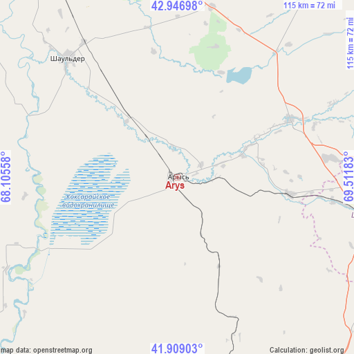
Arys GPS coordinates[2]
42° 25' 48.54" North, 68° 48' 31.32" East
| Map corner | latitude | longitude |
|---|---|---|
| Upper-left | 42.94698°, | 68.10558° |
| Center: | 42.43015°, | 68.8087° |
| Lower-right: | 41.90903°, | 69.51183° |
| Map W x H: | 115.4×115.4 km | = 71.7×71.7mi |
| max Lat: | 54.90596° ⇑96.3% North |
| Arys: | 42.43015° |
| min Lat: | ⇓3.7% South 40.66338° |
| min Long | Arys | max Long |
| 46.83361° | 68.8087° | 84.87144° |
| W 40.4%⇐ | ⇒59.6% E |
Elevation
Elevation of Arys is 239 m = 784 ft, and this is 117.5 m = 385 ft below average elevation for this country.
| Max E: |
1847 m = 6060 ft | 59.3% |
| Avg. | 356.5 m = 1170 ft | |
| Arys | 239 m = 784 ft | |
Min E: |
-26 m = -85 ft | 40.7% |
See also: Kazakhstan elevation on elevation.city.
Geographical zone
Arys is located in North temperate zone (between Tropic of Cancer and the Arctic Circle). Distance of this Northern Tropic circle is 2111.9 km =1312.3 mi to South.| Distance of | km | miles | from Arys |
|---|---|---|---|
| North Pole | 5289.3 | 3286.6 | to North |
| Arctic Circle | 2683.4 | 1667.4 | to North |
| Tropic Cancer | 2111.9 | 1312.3 | to South |
| Equator | 4717.8 | 2931.5 | to South |


Nearby cities:
15 places around Arys: (largest is in red/bold)
• Bayzhansay
121.9 km =75.7 mi,  47°
47°
• Belyye Vody
83.6 km =51.9 mi,  90°
90°
• Chayan
81.8 km =50.8 mi,  34°
34°
• Kentau
123.3 km =76.6 mi,  348°
348°
• Kokterek
118.8 km =73.8 mi, 86°
• Lenger
92.8 km =57.7 mi,  107°
107°
• Leninskoye
88.7 km =55.1 mi,  147°
147°
• Qogham
61.8 km =38.4 mi,  315°
315°
• Saryaghash
111.8 km =69.5 mi,  164°
164°
• Sastobe
98.5 km =61.2 mi,  82°
82°
• Sayram
79.2 km =49.2 mi,  100°
100°
• Shymkent
66.6 km =41.4 mi, 102°
• Temirlanovka
41.4 km =25.7 mi,  62°
62°
• Turkestan
106.6 km =66.2 mi,  334°
334°
• Tyul’kubas
122.2 km =75.9 mi, 87°
Sources, notices
• [Note1] Compared only with cities in Kazakhstan existing in our database
• [Src1] Map data: © OpenStreetMap contributors (CC-BY-SA)
• [Src2] Other city data from geonames.org with taken over terms of usage.
• [Src3] Geographical zone / Annual Mean Temperature by Robert A. Rohde @ Wikipedia
