Lenger geodata
Lenger (South Kazakhstan) is a seat of a second-order administrative division; located in Kazakhstan in Asia/Almaty (GMT+5) time zone. With population of 21,238 people, there are 63 cities with bigger population in this country. Compared to other cities in Kazakhstan, 97.8% of cities are located further ↑North; 52.6% of cities are located further →East and 94.1% of cities have lower elevation than Lenger. Note1


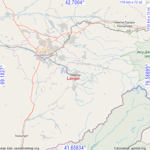
Lenger GPS coordinates[2]
42° 10' 53.472" North, 69° 53' 8.952" East
| Map corner | latitude | longitude |
|---|---|---|
| Upper-left | 42.7004°, | 69.1827° |
| Center: | 42.18152°, | 69.88582° |
| Lower-right: | 41.65834°, | 70.58895° |
| Map W x H: | 115.9×115.9 km | = 72×72mi |
| max Lat: | 54.90596° ⇑97.8% North |
| Lenger: | 42.18152° |
| min Lat: | ⇓2.2% South 40.66338° |
| min Long | Lenger | max Long |
| 46.83361° | 69.88582° | 84.87144° |
| W 47.4%⇐ | ⇒52.6% E |
Elevation
Elevation of Lenger is 777 m = 2549 ft, and this is 420.5 m = 1380 ft above average elevation for this country.
| Max E: |
1847 m = 6060 ft | 5.9% |
| Lenger | 777 m 2549 ft | |
| Avg. | 356.5 m = 1170 ft | |
Min E: |
-26 m = -85 ft | 94.1% |
See also: Kazakhstan elevation on elevation.city.
Geographical zone
Lenger is located in North temperate zone (between Tropic of Cancer and the Arctic Circle). Distance of this Northern Tropic circle is 2084.2 km =1295.1 mi to South.| Distance of | km | miles | from Lenger |
|---|---|---|---|
| North Pole | 5316.9 | 3303.8 | to North |
| Arctic Circle | 2711 | 1684.5 | to North |
| Tropic Cancer | 2084.2 | 1295.1 | to South |
| Equator | 4690.1 | 2914.3 | to South |


Nearby cities:
15 places around Lenger: (largest is in red/bold)
• Arys
92.8 km =57.7 mi,  287°
287°
• Bayzhansay
109.6 km =68.1 mi,  1°
1°
• Belyye Vody
27.2 km =16.9 mi,  349°
349°
• Chayan
103.4 km =64.2 mi,  336°
336°
• Karatau
120.6 km =74.9 mi,  23°
23°
• Kokterek
46.2 km =28.7 mi,  41°
41°
• Leninskoye
62.9 km =39.1 mi,  221°
221°
• Saryaghash
99.8 km =62 mi, 216°
• Sastobe
42.4 km =26.3 mi,  12°
12°
• Sayram
17.1 km =10.6 mi,  321°
321°
• Shymkent
27 km =16.8 mi,  299°
299°
• Temirlanovka
69.4 km =43.1 mi,  312°
312°
• Turar Ryskulov
54.6 km =33.9 mi, 44°
• Tyul’kubas
47.8 km =29.7 mi, 44°
• Zhabagly
56.4 km =35 mi,  59°
59°
Sources, notices
• [Note1] Compared only with cities in Kazakhstan existing in our database
• [Src1] Map data: © OpenStreetMap contributors (CC-BY-SA)
• [Src2] Other city data from geonames.org with taken over terms of usage.
• [Src3] Geographical zone / Annual Mean Temperature by Robert A. Rohde @ Wikipedia
