Semey geodata
Semey (East Kazakhstan) is a populated place; located in Kazakhstan in Asia/Almaty (GMT+5) time zone. With population of 292,780 people, there are 8 cities with bigger population in this country. Compared to other cities in Kazakhstan, 70.4% of cities are located further ↓South; 88.9% of cities are located further ←West and 63.3% of cities have higher elevation than Semey. Note1


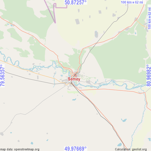
Semey GPS coordinates[2]
50° 25' 36.3" North, 80° 16' 0.084" East
| Map corner | latitude | longitude |
|---|---|---|
| Upper-left | 50.87257°, | 79.56357° |
| Center: | 50.42675°, | 80.26669° |
| Lower-right: | 49.97669°, | 80.96982° |
| Map W x H: | 99.6×99.6 km | = 61.9×61.9mi |
| max Lat: | 54.90596° ⇑29.6% North |
| Semey: | 50.42675° |
| min Lat: | ⇓70.4% South 40.66338° |
| min Long | Semey | max Long |
| 46.83361° | 80.26669° | 84.87144° |
| W 88.9%⇐ | ⇒11.1% E |
Elevation
Elevation of Semey is 211 m = 692 ft, and this is 145.5 m = 477 ft below average elevation for this country.
| Max E: |
1847 m = 6060 ft | 63.3% |
| Avg. | 356.5 m = 1170 ft | |
| Semey | 211 m = 692 ft | |
Min E: |
-26 m = -85 ft | 36.7% |
See also: Semey elevation on elevation.city.
Geographical zone
Semey is located in North temperate zone (between Tropic of Cancer and the Arctic Circle). Distance of this North polar circle is 1794.2 km =1114.9 mi to North.| Distance of | km | miles | from Semey |
|---|---|---|---|
| North Pole | 4400.1 | 2734.1 | to North |
| Arctic Circle | 1794.2 | 1114.9 | to North |
| Tropic Cancer | 3001 | 1864.7 | to South |
| Equator | 5606.9 | 3484 | to South |


Nearby cities:
15 places around Semey: (largest is in red/bold)
• Altayskiy
150.1 km =93.3 mi,  97°
97°
• Auezov
123 km =76.4 mi,  130°
130°
• Belousovka
163.7 km =101.7 mi, 101°
• Borodulikha
56.9 km =35.4 mi,  55°
55°
• Georgīevka
154 km =95.7 mi,  142°
142°
• Glubokoye
148.7 km =92.4 mi, 102°
• Kurchatov
127.1 km =79 mi,  286°
286°
• Qaraūyl
180.1 km =111.9 mi,  203°
203°
• Shar
108.8 km =67.6 mi,  149°
149°
• Shemonaīkha
118.4 km =73.6 mi,  79°
79°
• Suykbulak
97.4 km =60.5 mi, 145°
• Ust-Kamenogorsk
174 km =108.1 mi,  106°
106°
• Zhalghyztobe
151.4 km =94.1 mi, 153°
• Zhezkent
95.4 km =59.3 mi,  53°
53°
• Ūst’-Talovka
112.8 km =70.1 mi, 83°
In other languages:
- In France: Semeï
- In German: Semei
- In Italian: Semej
- In Russian: Семей
- In Chinese: 塞米伊
Sources, notices
• [Note1] Compared only with cities in Kazakhstan existing in our database
• [Src1] Map data: © OpenStreetMap contributors (CC-BY-SA)
• [Src2] Other city data from geonames.org with taken over terms of usage.
• [Src3] Geographical zone / Annual Mean Temperature by Robert A. Rohde @ Wikipedia
