Qaraūyl geodata
Qaraūyl (East Kazakhstan) is a populated place; located in Kazakhstan in Asia/Almaty (GMT+5) time zone. With population of 5,261 people, there are 187 cities with bigger population in this country. Compared to other cities in Kazakhstan, 52.2% of cities are located further ↓South; 87% of cities are located further ←West and 83.7% of cities have lower elevation than Qaraūyl. Note1


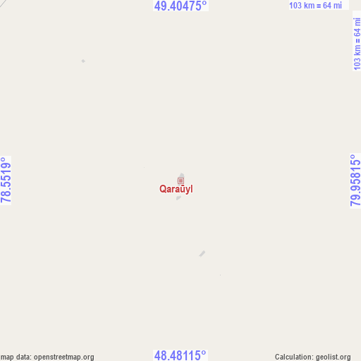
Qaraūyl GPS coordinates[2]
48° 56' 42.324" North, 79° 15' 18.072" East
| Map corner | latitude | longitude |
|---|---|---|
| Upper-left | 49.40475°, | 78.5519° |
| Center: | 48.94509°, | 79.25502° |
| Lower-right: | 48.48115°, | 79.95815° |
| Map W x H: | 102.7×102.7 km | = 63.8×63.8mi |
| max Lat: | 54.90596° ⇑47.8% North |
| Qaraūyl: | 48.94509° |
| min Lat: | ⇓52.2% South 40.66338° |
| min Long | Qaraūyl | max Long |
| 46.83361° | 79.25502° | 84.87144° |
| W 87%⇐ | ⇒13% E |
Elevation
Elevation of Qaraūyl is 622 m = 2041 ft, and this is 265.5 m = 871 ft above average elevation for this country.
| Max E: |
1847 m = 6060 ft | 16.3% |
| Qaraūyl | 622 m 2041 ft | |
| Avg. | 356.5 m = 1170 ft | |
Min E: |
-26 m = -85 ft | 83.7% |
See also: Kazakhstan elevation on elevation.city.
Geographical zone
Qaraūyl is located in North temperate zone (between Tropic of Cancer and the Arctic Circle). Distance of this North polar circle is 1959 km =1217.3 mi to North.| Distance of | km | miles | from Qaraūyl |
|---|---|---|---|
| North Pole | 4564.9 | 2836.5 | to North |
| Arctic Circle | 1959 | 1217.3 | to North |
| Tropic Cancer | 2836.3 | 1762.4 | to South |
| Equator | 5442.2 | 3381.6 | to South |


Nearby cities:
15 places around Qaraūyl: (largest is in red/bold)
• Aqtoghay
223.9 km =139.1 mi,  172°
172°
• Auezov
188.7 km =117.3 mi,  63°
63°
• Ayagoz
139.5 km =86.7 mi,  141°
141°
• Borodulikha
230.9 km =143.5 mi,  31°
31°
• Georgīevka
173.9 km =108.1 mi,  75°
75°
• Glubokoye
257.3 km =159.9 mi, 58°
• Kokpekty
231.1 km =143.6 mi,  95°
95°
• Kurchatov
207.8 km =129.1 mi,  345°
345°
• Priisk Boko
174.8 km =108.6 mi,  85°
85°
• Sarykamys
135.2 km =84 mi,  197°
197°
• Semey
180.1 km =111.9 mi,  23°
23°
• Shar
148.4 km =92.2 mi, 61°
• Suykbulak
155.2 km =96.4 mi, 56°
• Zhalghyztobe
145.8 km =90.6 mi, 78°
• Ūst’-Talovka
258 km =160.3 mi,  46°
46°
Sources, notices
• [Note1] Compared only with cities in Kazakhstan existing in our database
• [Src1] Map data: © OpenStreetMap contributors (CC-BY-SA)
• [Src2] Other city data from geonames.org with taken over terms of usage.
• [Src3] Geographical zone / Annual Mean Temperature by Robert A. Rohde @ Wikipedia
