Balqash geodata
Balqash (Karaganda) is a populated place; located in Kazakhstan in Asia/Almaty (GMT+5) time zone. With population of 81,364 people, there are 23 cities with bigger population in this country. Compared to other cities in Kazakhstan, 63.3% of cities are located further ↑North; 72.6% of cities are located further ←West and 57% of cities have lower elevation than Balqash. Note1


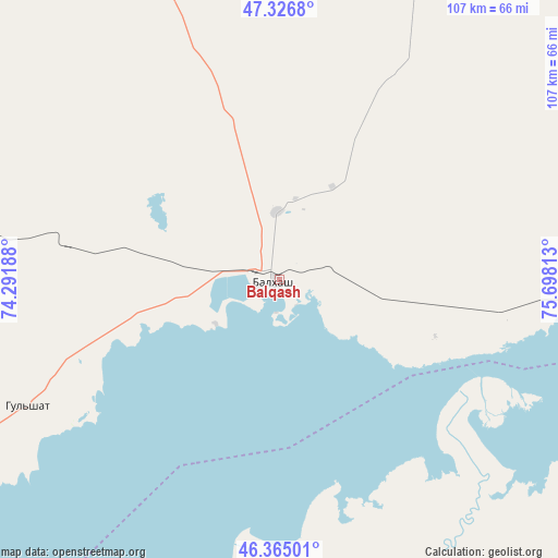
Balqash GPS coordinates[2]
46° 50' 53.016" North, 74° 59' 42" East
| Map corner | latitude | longitude |
|---|---|---|
| Upper-left | 47.3268°, | 74.29188° |
| Center: | 46.84806°, | 74.995° |
| Lower-right: | 46.36501°, | 75.69813° |
| Map W x H: | 106.9×106.9 km | = 66.4×66.4mi |
| max Lat: | 54.90596° ⇑63.3% North |
| Balqash: | 46.84806° |
| min Lat: | ⇓36.7% South 40.66338° |
| min Long | Balqash | max Long |
| 46.83361° | 74.995° | 84.87144° |
| W 72.6%⇐ | ⇒27.4% E |
Elevation
Elevation of Balqash is 372 m = 1220 ft, and this is 15.5 m = 51 ft above average elevation for this country.
| Max E: |
1847 m = 6060 ft | 43% |
| Balqash | 372 m 1220 ft | |
| Avg. | 356.5 m = 1170 ft | |
Min E: |
-26 m = -85 ft | 57% |
See also: Balqash elevation on elevation.city.
Geographical zone
Balqash is located in North temperate zone (between Tropic of Cancer and the Arctic Circle). Distance of this North polar circle is 2192.2 km =1362.2 mi to North.| Distance of | km | miles | from Balqash |
|---|---|---|---|
| North Pole | 4798 | 2981.3 | to North |
| Arctic Circle | 2192.2 | 1362.2 | to North |
| Tropic Cancer | 2603.1 | 1617.5 | to South |
| Equator | 5209 | 3236.7 | to South |


Nearby cities:
15 places around Balqash: (largest is in red/bold)
• Aksu-Ayuly
235.2 km =146.1 mi,  335°
335°
• Aktau
209.3 km =130.1 mi,  309°
309°
• Aktogay
148.4 km =92.2 mi,  8°
8°
• Aqadyr
224.4 km =139.4 mi, 314°
• Aqshataū
145.2 km =90.2 mi,  330°
330°
• Gülshat
54.4 km =33.8 mi,  243°
243°
• Karabas
98.3 km =61.1 mi,  110°
110°
• Moyynty
130.2 km =80.9 mi,  288°
288°
• Mynaral
188.5 km =117.1 mi,  212°
212°
• Priozersk
134.4 km =83.5 mi,  227°
227°
• Saryshaghan
132.9 km =82.6 mi, 232°
• Sayaq
173.3 km =107.7 mi,  84°
84°
• Shashūbay
4.9 km =3 mi,  135°
135°
• Verkhniye Kayrakty
240.8 km =149.6 mi, 327°
• Ülken
198.1 km =123.1 mi,  203°
203°
Sources, notices
• [Note1] Compared only with cities in Kazakhstan existing in our database
• [Src1] Map data: © OpenStreetMap contributors (CC-BY-SA)
• [Src2] Other city data from geonames.org with taken over terms of usage.
• [Src3] Geographical zone / Annual Mean Temperature by Robert A. Rohde @ Wikipedia
