Priozersk geodata
Priozersk (Karaganda) is a populated place; located in Kazakhstan in Asia/Almaty (GMT+5) time zone. With population of 13,457 people, there are 89 cities with bigger population in this country. Compared to other cities in Kazakhstan, 67% of cities are located further ↑North; 70% of cities are located further ←West and 54.1% of cities have lower elevation than Priozersk. Note1


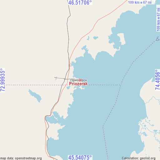
Priozersk GPS coordinates[2]
46° 1' 51.816" North, 73° 42' 8.892" East
| Map corner | latitude | longitude |
|---|---|---|
| Upper-left | 46.51706°, | 72.99935° |
| Center: | 46.03106°, | 73.70247° |
| Lower-right: | 45.54075°, | 74.4056° |
| Map W x H: | 108.6×108.6 km | = 67.5×67.5mi |
| max Lat: | 54.90596° ⇑67% North |
| Priozersk: | 46.03106° |
| min Lat: | ⇓33% South 40.66338° |
| min Long | Priozersk | max Long |
| 46.83361° | 73.70247° | 84.87144° |
| W 70%⇐ | ⇒30% E |
Elevation
Elevation of Priozersk is 358 m = 1175 ft, and this is 1.5 m = 5 ft above average elevation for this country.
| Max E: |
1847 m = 6060 ft | 45.9% |
| Priozersk | 358 m 1175 ft | |
| Avg. | 356.5 m = 1170 ft | |
Min E: |
-26 m = -85 ft | 54.1% |
See also: Kazakhstan elevation on elevation.city.
Geographical zone
Priozersk is located in North temperate zone (between Tropic of Cancer and the Arctic Circle). Distance of this North polar circle is 2283 km =1418.6 mi to North.| Distance of | km | miles | from Priozersk |
|---|---|---|---|
| North Pole | 4888.9 | 3037.8 | to North |
| Arctic Circle | 2283 | 1418.6 | to North |
| Tropic Cancer | 2512.3 | 1561.1 | to South |
| Equator | 5118.2 | 3180.3 | to South |


Nearby cities:
15 places around Priozersk: (largest is in red/bold)
• Aktau
232.2 km =144.3 mi,  343°
343°
• Aqbaqay
135.2 km =84 mi,  211°
211°
• Aqshataū
219.4 km =136.3 mi,  7°
7°
• Bakanas
242.3 km =150.6 mi,  124°
124°
• Balqash
134.4 km =83.5 mi,  47°
47°
• Gülshat
83.4 km =51.8 mi,  37°
37°
• Karabas
199.9 km =124.2 mi,  73°
73°
• Khantaū
200.7 km =124.7 mi,  177°
177°
• Moyynkum
203.2 km =126.3 mi,  197°
197°
• Moyynty
134.8 km =83.8 mi,  349°
349°
• Mynaral
68.4 km =42.5 mi, 181°
• Saryshaghan
11.7 km =7.3 mi,  326°
326°
• Shashūbay
134.7 km =83.7 mi, 49°
• Zhambyl
219.3 km =136.3 mi,  306°
306°
• Ülken
93.6 km =58.2 mi,  166°
166°
Sources, notices
• [Note1] Compared only with cities in Kazakhstan existing in our database
• [Src1] Map data: © OpenStreetMap contributors (CC-BY-SA)
• [Src2] Other city data from geonames.org with taken over terms of usage.
• [Src3] Geographical zone / Annual Mean Temperature by Robert A. Rohde @ Wikipedia
