Gülshat geodata
Gülshat (Karaganda) is a populated place; located in Kazakhstan in Asia/Almaty (GMT+5) time zone. With population of 891 people, there are 265 cities with bigger population in this country. Compared to other cities in Kazakhstan, 64.8% of cities are located further ↑North; 71.9% of cities are located further ←West and 57.4% of cities have lower elevation than Gülshat. Note1


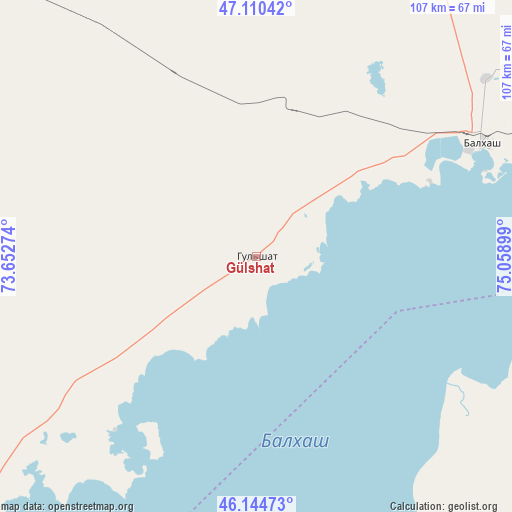
Gülshat GPS coordinates[2]
46° 37' 47.028" North, 74° 21' 21.096" East
| Map corner | latitude | longitude |
|---|---|---|
| Upper-left | 47.11042°, | 73.65274° |
| Center: | 46.62973°, | 74.35586° |
| Lower-right: | 46.14473°, | 75.05899° |
| Map W x H: | 107.4×107.4 km | = 66.7×66.7mi |
| max Lat: | 54.90596° ⇑64.8% North |
| Gülshat: | 46.62973° |
| min Lat: | ⇓35.2% South 40.66338° |
| min Long | Gülshat | max Long |
| 46.83361° | 74.35586° | 84.87144° |
| W 71.9%⇐ | ⇒28.1% E |
Elevation
Elevation of Gülshat is 375 m = 1230 ft, and this is 18.5 m = 61 ft above average elevation for this country.
| Max E: |
1847 m = 6060 ft | 42.6% |
| Gülshat | 375 m 1230 ft | |
| Avg. | 356.5 m = 1170 ft | |
Min E: |
-26 m = -85 ft | 57.4% |
See also: Kazakhstan elevation on elevation.city.
Geographical zone
Gülshat is located in North temperate zone (between Tropic of Cancer and the Arctic Circle). Distance of this North polar circle is 2216.4 km =1377.2 mi to North.| Distance of | km | miles | from Gülshat |
|---|---|---|---|
| North Pole | 4822.3 | 2996.4 | to North |
| Arctic Circle | 2216.4 | 1377.2 | to North |
| Tropic Cancer | 2578.8 | 1602.4 | to South |
| Equator | 5184.7 | 3221.6 | to South |


Nearby cities:
15 places around Gülshat: (largest is in red/bold)
• Aktau
193.7 km =120.4 mi,  323°
323°
• Aktogay
185.1 km =115 mi,  22°
22°
• Aqadyr
213.4 km =132.6 mi,  328°
328°
• Aqbaqay
218.4 km =135.7 mi,  213°
213°
• Aqshataū
152.8 km =94.9 mi,  351°
351°
• Balqash
54.4 km =33.8 mi,  63°
63°
• Karabas
141.3 km =87.8 mi,  94°
94°
• Moyynty
99.8 km =62 mi,  311°
311°
• Mynaral
144.6 km =89.9 mi,  201°
201°
• Priozersk
83.4 km =51.8 mi,  217°
217°
• Saryshaghan
80.1 km =49.8 mi, 224°
• Sayaq
225.3 km =140 mi,  79°
79°
• Shashūbay
56.2 km =34.9 mi,  68°
68°
• Zhambyl
233.7 km =145.2 mi,  285°
285°
• Ülken
160.3 km =99.6 mi,  190°
190°
Sources, notices
• [Note1] Compared only with cities in Kazakhstan existing in our database
• [Src1] Map data: © OpenStreetMap contributors (CC-BY-SA)
• [Src2] Other city data from geonames.org with taken over terms of usage.
• [Src3] Geographical zone / Annual Mean Temperature by Robert A. Rohde @ Wikipedia
