Shashūbay geodata
Shashūbay (Karaganda) is a populated place; located in Kazakhstan in Asia/Almaty (GMT+5) time zone. With population of 3,563 people, there are 222 cities with bigger population in this country. Compared to other cities in Kazakhstan, 63.7% of cities are located further ↑North; 73% of cities are located further ←West and 52.2% of cities have lower elevation than Shashūbay. Note1


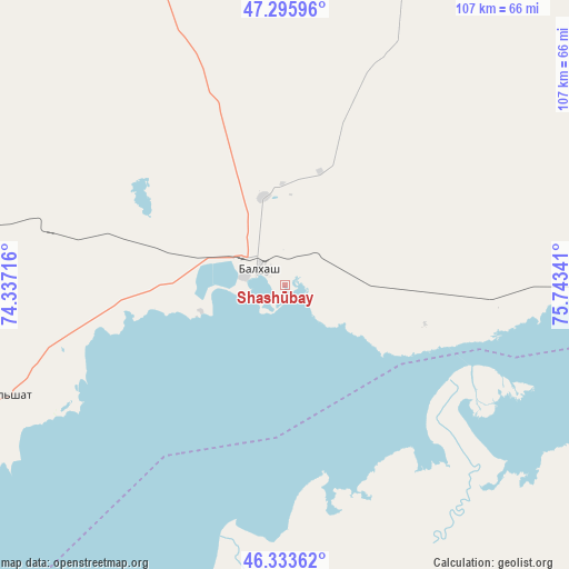
Shashūbay GPS coordinates[2]
46° 49' 0.984" North, 75° 2' 25.008" East
| Map corner | latitude | longitude |
|---|---|---|
| Upper-left | 47.29596°, | 74.33716° |
| Center: | 46.81694°, | 75.04028° |
| Lower-right: | 46.33362°, | 75.74341° |
| Map W x H: | 107×107 km | = 66.5×66.5mi |
| max Lat: | 54.90596° ⇑63.7% North |
| Shashūbay: | 46.81694° |
| min Lat: | ⇓36.3% South 40.66338° |
| min Long | Shashūbay | max Long |
| 46.83361° | 75.04028° | 84.87144° |
| W 73%⇐ | ⇒27% E |
Elevation
Elevation of Shashūbay is 341 m = 1119 ft, and this is 15.5 m = 51 ft below average elevation for this country.
| Max E: |
1847 m = 6060 ft | 47.8% |
| Avg. | 356.5 m = 1170 ft | |
| Shashūbay | 341 m = 1119 ft | |
Min E: |
-26 m = -85 ft | 52.2% |
See also: Kazakhstan elevation on elevation.city.
Geographical zone
Shashūbay is located in North temperate zone (between Tropic of Cancer and the Arctic Circle). Distance of this North polar circle is 2195.6 km =1364.3 mi to North.| Distance of | km | miles | from Shashūbay |
|---|---|---|---|
| North Pole | 4801.5 | 2983.5 | to North |
| Arctic Circle | 2195.6 | 1364.3 | to North |
| Tropic Cancer | 2599.6 | 1615.3 | to South |
| Equator | 5205.6 | 3234.6 | to South |


Nearby cities:
15 places around Shashūbay: (largest is in red/bold)
• Aksu-Ayuly
239.8 km =149 mi,  334°
334°
• Aktau
214.1 km =133 mi,  309°
309°
• Aktogay
151.3 km =94 mi,  7°
7°
• Aqadyr
229.3 km =142.5 mi, 314°
• Aqshataū
149.9 km =93.1 mi, 330°
• Bakanas
242.9 km =150.9 mi,  156°
156°
• Balqash
4.9 km =3 mi,  315°
315°
• Gülshat
56.2 km =34.9 mi,  248°
248°
• Karabas
93.9 km =58.3 mi,  109°
109°
• Moyynty
134.6 km =83.6 mi,  289°
289°
• Mynaral
187.6 km =116.6 mi,  213°
213°
• Priozersk
134.7 km =83.7 mi,  229°
229°
• Saryshaghan
133.7 km =83.1 mi, 234°
• Sayaq
170.3 km =105.8 mi,  83°
83°
• Ülken
196.4 km =122 mi,  204°
204°
Sources, notices
• [Note1] Compared only with cities in Kazakhstan existing in our database
• [Src1] Map data: © OpenStreetMap contributors (CC-BY-SA)
• [Src2] Other city data from geonames.org with taken over terms of usage.
• [Src3] Geographical zone / Annual Mean Temperature by Robert A. Rohde @ Wikipedia
