Karasu geodata
Karasu (Qostanay) is a populated place; located in Kazakhstan in Asia/Qostanay (GMT+5) time zone. With population of 3,220 people, there are 225 cities with bigger population in this country. Compared to other cities in Kazakhstan, 88.5% of cities are located further ↓South; 72.2% of cities are located further →East and 64.8% of cities have higher elevation than Karasu. Note1


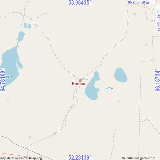
Karasu GPS coordinates[2]
52° 39' 35.82" North, 65° 29' 3.156" East
| Map corner | latitude | longitude |
|---|---|---|
| Upper-left | 53.08435°, | 64.78109° |
| Center: | 52.65995°, | 65.48421° |
| Lower-right: | 52.23139°, | 66.18734° |
| Map W x H: | 94.8×94.8 km | = 58.9×58.9mi |
| max Lat: | 54.90596° ⇑11.5% North |
| Karasu: | 52.65995° |
| min Lat: | ⇓88.5% South 40.66338° |
| min Long | Karasu | max Long |
| 46.83361° | 65.48421° | 84.87144° |
| W 27.8%⇐ | ⇒72.2% E |
Elevation
Elevation of Karasu is 206 m = 676 ft, and this is 150.5 m = 494 ft below average elevation for this country.
| Max E: |
1847 m = 6060 ft | 64.8% |
| Avg. | 356.5 m = 1170 ft | |
| Karasu | 206 m = 676 ft | |
Min E: |
-26 m = -85 ft | 35.2% |
See also: Kazakhstan elevation on elevation.city.
Geographical zone
Karasu is located in North temperate zone (between Tropic of Cancer and the Arctic Circle). Distance of this North polar circle is 1545.9 km =960.6 mi to North.| Distance of | km | miles | from Karasu |
|---|---|---|---|
| North Pole | 4151.8 | 2579.8 | to North |
| Arctic Circle | 1545.9 | 960.6 | to North |
| Tropic Cancer | 3249.3 | 2019 | to South |
| Equator | 5855.2 | 3638.3 | to South |


Nearby cities:
15 places around Karasu: (largest is in red/bold)
• Borovskoy
152.9 km =95 mi,  325°
325°
• Derzhavīnsk
182.7 km =113.5 mi,  161°
161°
• Esil
100.5 km =62.4 mi,  141°
141°
• Kostanay
139 km =86.4 mi,  296°
296°
• Krasnogorskiy
84 km =52.2 mi,  123°
123°
• Novoishimskiy
104.9 km =65.2 mi,  55°
55°
• Qashar
191.9 km =119.2 mi,  294°
294°
• Qusmuryn
62.9 km =39.1 mi,  248°
248°
• Rudnyy
162.8 km =101.2 mi,  282°
282°
• Sergeyevka
186.6 km =115.9 mi,  43°
43°
• Shantobe
183.3 km =113.9 mi,  97°
97°
• Timiryazevo
138.4 km =86 mi,  28°
28°
• Volodarskoye
75 km =46.6 mi,  89°
89°
• Volodarskoye
189 km =117.4 mi,  68°
68°
• Zhaqsy
149.9 km =93.1 mi, 123°
Sources, notices
• [Note1] Compared only with cities in Kazakhstan existing in our database
• [Src1] Map data: © OpenStreetMap contributors (CC-BY-SA)
• [Src2] Other city data from geonames.org with taken over terms of usage.
• [Src3] Geographical zone / Annual Mean Temperature by Robert A. Rohde @ Wikipedia
