Rudnyy geodata
Rudnyy (Qostanay) is a populated place; located in Kazakhstan in Asia/Qostanay (GMT+5) time zone. With population of 124,000 people, there are 17 cities with bigger population in this country. Compared to other cities in Kazakhstan, 90.7% of cities are located further ↓South; 75.9% of cities are located further →East and 72.2% of cities have higher elevation than Rudnyy. Note1


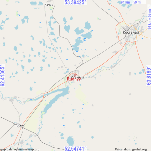
Rudnyy GPS coordinates[2]
52° 58' 22.44" North, 63° 7' 0.372" East
| Map corner | latitude | longitude |
|---|---|---|
| Upper-left | 53.39425°, | 62.41365° |
| Center: | 52.9729°, | 63.11677° |
| Lower-right: | 52.54741°, | 63.8199° |
| Map W x H: | 94.2×94.2 km | = 58.5×58.5mi |
| max Lat: | 54.90596° ⇑9.3% North |
| Rudnyy: | 52.9729° |
| min Lat: | ⇓90.7% South 40.66338° |
| min Long | Rudnyy | max Long |
| 46.83361° | 63.11677° | 84.87144° |
| W 24.1%⇐ | ⇒75.9% E |
Elevation
Elevation of Rudnyy is 167 m = 548 ft, and this is 189.5 m = 622 ft below average elevation for this country.
| Max E: |
1847 m = 6060 ft | 72.2% |
| Avg. | 356.5 m = 1170 ft | |
| Rudnyy | 167 m = 548 ft | |
Min E: |
-26 m = -85 ft | 27.8% |
See also: Rudnyy elevation on elevation.city.
Geographical zone
Rudnyy is located in North temperate zone (between Tropic of Cancer and the Arctic Circle). Distance of this North polar circle is 1511.1 km =939 mi to North.| Distance of | km | miles | from Rudnyy |
|---|---|---|---|
| North Pole | 4117 | 2558.2 | to North |
| Arctic Circle | 1511.1 | 939 | to North |
| Tropic Cancer | 3284.1 | 2040.6 | to South |
| Equator | 5890 | 3659.9 | to South |


Nearby cities:
15 places around Rudnyy: (largest is in red/bold)
• Ayat
42.8 km =26.6 mi,  249°
249°
• Borovskoy
115.4 km =71.7 mi,  37°
37°
• Dzhetygara
156.1 km =97 mi,  236°
236°
• Fyodorovka
79.1 km =49.2 mi,  339°
339°
• Karasu
162.8 km =101.2 mi,  102°
102°
• Komsomolets
111.4 km =69.2 mi,  320°
320°
• Kostanay
43.3 km =26.9 mi,  51°
51°
• Krasnogorskiy
243.6 km =151.4 mi,  109°
109°
• Lisakovsk
63 km =39.1 mi,  221°
221°
• Ordzhonikidze
109.1 km =67.8 mi, 237°
• Qashar
46.9 km =29.1 mi, 339°
• Qusmuryn
116.7 km =72.5 mi,  119°
119°
• Timiryazevo
239.8 km =149 mi,  68°
68°
• Tobol
47 km =29.2 mi,  228°
228°
• Volodarskoye
236.4 km =146.9 mi, 98°
Sources, notices
• [Note1] Compared only with cities in Kazakhstan existing in our database
• [Src1] Map data: © OpenStreetMap contributors (CC-BY-SA)
• [Src2] Other city data from geonames.org with taken over terms of usage.
• [Src3] Geographical zone / Annual Mean Temperature by Robert A. Rohde @ Wikipedia
