Būrabay geodata
Būrabay (Soltüstik Qazaqstan) is a populated place; located in Kazakhstan in Asia/Almaty (GMT+5) time zone. With population of 6,500 people, there are 163 cities with bigger population in this country. Compared to other cities in Kazakhstan, 91.5% of cities are located further ↓South; 50% of cities are located further ←West and 50.4% of cities have higher elevation than Būrabay. Note1


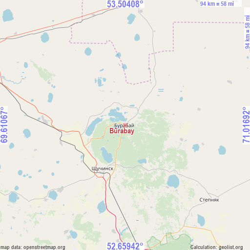
Būrabay GPS coordinates[2]
53° 5' 1.752" North, 70° 18' 49.644" East
| Map corner | latitude | longitude |
|---|---|---|
| Upper-left | 53.50408°, | 69.61067° |
| Center: | 53.08382°, | 70.31379° |
| Lower-right: | 52.65942°, | 71.01692° |
| Map W x H: | 93.9×93.9 km | = 58.3×58.3mi |
| max Lat: | 54.90596° ⇑8.5% North |
| Būrabay: | 53.08382° |
| min Lat: | ⇓91.5% South 40.66338° |
| min Long | Būrabay | max Long |
| 46.83361° | 70.31379° | 84.87144° |
| W 50%⇐ | ⇒50% E |
Elevation
Elevation of Būrabay is 321 m = 1053 ft, and this is 35.5 m = 116 ft below average elevation for this country.
| Max E: |
1847 m = 6060 ft | 50.4% |
| Avg. | 356.5 m = 1170 ft | |
| Būrabay | 321 m = 1053 ft | |
Min E: |
-26 m = -85 ft | 49.6% |
See also: Kazakhstan elevation on elevation.city.
Geographical zone
Būrabay is located in North temperate zone (between Tropic of Cancer and the Arctic Circle). Distance of this North polar circle is 1498.8 km =931.3 mi to North.| Distance of | km | miles | from Būrabay |
|---|---|---|---|
| North Pole | 4104.7 | 2550.5 | to North |
| Arctic Circle | 1498.8 | 931.3 | to North |
| Tropic Cancer | 3296.4 | 2048.3 | to South |
| Equator | 5902.4 | 3667.6 | to South |


Nearby cities:
15 places around Būrabay: (largest is in red/bold)
• Akkol
128.5 km =79.8 mi,  160°
160°
• Akkol’
53.1 km =33 mi,  296°
296°
• Aksu
131.5 km =81.7 mi,  122°
122°
• Balkashino
122.4 km =76.1 mi,  239°
239°
• Birlestik
141.5 km =87.9 mi,  293°
293°
• Kokshetau
64.8 km =40.3 mi, 290°
• Kzyltu
147.8 km =91.8 mi,  65°
65°
• Makinsk
50.6 km =31.4 mi,  171°
171°
• Shchuchinsk
18.4 km =11.4 mi,  206°
206°
• Stepnogorsk
133.4 km =82.9 mi,  127°
127°
• Stepnyak
42.2 km =26.2 mi, 131°
• Taiynsha
92.3 km =57.4 mi,  336°
336°
• Talshik
120.4 km =74.8 mi,  59°
59°
• Volodarskoye
149 km =92.6 mi,  278°
278°
• Zavodskoy
133.2 km =82.8 mi, 120°
Sources, notices
• [Note1] Compared only with cities in Kazakhstan existing in our database
• [Src1] Map data: © OpenStreetMap contributors (CC-BY-SA)
• [Src2] Other city data from geonames.org with taken over terms of usage.
• [Src3] Geographical zone / Annual Mean Temperature by Robert A. Rohde @ Wikipedia
