Balkashino geodata
Balkashino (Aqmola) is a populated place; located in Kazakhstan in Asia/Almaty (GMT+5) time zone. With population of 6,147 people, there are 168 cities with bigger population in this country. Compared to other cities in Kazakhstan, 87.4% of cities are located further ↓South; 60.4% of cities are located further →East and 56.7% of cities have lower elevation than Balkashino. Note1


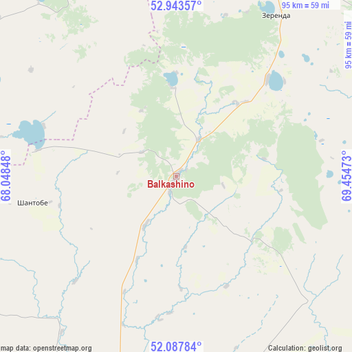
Balkashino GPS coordinates[2]
52° 31' 4.044" North, 68° 45' 5.76" East
| Map corner | latitude | longitude |
|---|---|---|
| Upper-left | 52.94357°, | 68.04848° |
| Center: | 52.51779°, | 68.7516° |
| Lower-right: | 52.08784°, | 69.45473° |
| Map W x H: | 95.1×95.1 km | = 59.1×59.1mi |
| max Lat: | 54.90596° ⇑12.6% North |
| Balkashino: | 52.51779° |
| min Lat: | ⇓87.4% South 40.66338° |
| min Long | Balkashino | max Long |
| 46.83361° | 68.7516° | 84.87144° |
| W 39.6%⇐ | ⇒60.4% E |
Elevation
Elevation of Balkashino is 371 m = 1217 ft, and this is 14.5 m = 48 ft above average elevation for this country.
| Max E: |
1847 m = 6060 ft | 43.3% |
| Balkashino | 371 m 1217 ft | |
| Avg. | 356.5 m = 1170 ft | |
Min E: |
-26 m = -85 ft | 56.7% |
See also: Kazakhstan elevation on elevation.city.
Geographical zone
Balkashino is located in North temperate zone (between Tropic of Cancer and the Arctic Circle). Distance of this North polar circle is 1561.7 km =970.4 mi to North.| Distance of | km | miles | from Balkashino |
|---|---|---|---|
| North Pole | 4167.6 | 2589.6 | to North |
| Arctic Circle | 1561.7 | 970.4 | to North |
| Tropic Cancer | 3233.5 | 2009.2 | to South |
| Equator | 5839.4 | 3628.4 | to South |


Nearby cities:
15 places around Balkashino: (largest is in red/bold)
• Akkol’
103.6 km =64.4 mi,  33°
33°
• Astrakhan
131 km =81.4 mi,  146°
146°
• Atbasar
83.5 km =51.9 mi,  198°
198°
• Atbasar
84.8 km =52.7 mi, 199°
• Birlestik
121.5 km =75.5 mi,  347°
347°
• Būrabay
122.4 km =76.1 mi,  59°
59°
• Kokshetau
95.6 km =59.4 mi, 27°
• Makinsk
113.4 km =70.5 mi,  83°
83°
• Novoishimskiy
153.1 km =95.1 mi,  299°
299°
• Shantobe
39.7 km =24.7 mi,  259°
259°
• Shchuchinsk
107.4 km =66.7 mi, 64°
• Stepnyak
141.8 km =88.1 mi, 75°
• Volodarskoye
96.5 km =60 mi,  333°
333°
• Volodarskoye
146.4 km =91 mi,  276°
276°
• Zhaqsy
118.8 km =73.8 mi,  235°
235°
Sources, notices
• [Note1] Compared only with cities in Kazakhstan existing in our database
• [Src1] Map data: © OpenStreetMap contributors (CC-BY-SA)
• [Src2] Other city data from geonames.org with taken over terms of usage.
• [Src3] Geographical zone / Annual Mean Temperature by Robert A. Rohde @ Wikipedia
