Kokshetau geodata
Kokshetau (Aqmola) is a seat of a first-order administrative division; located in Kazakhstan in Asia/Almaty (GMT+5) time zone. With population of 124,444 people, there are 16 cities with bigger population in this country. Compared to other cities in Kazakhstan, 92.6% of cities are located further ↓South; 56.3% of cities are located further →East and 60.4% of cities have higher elevation than Kokshetau. Note1


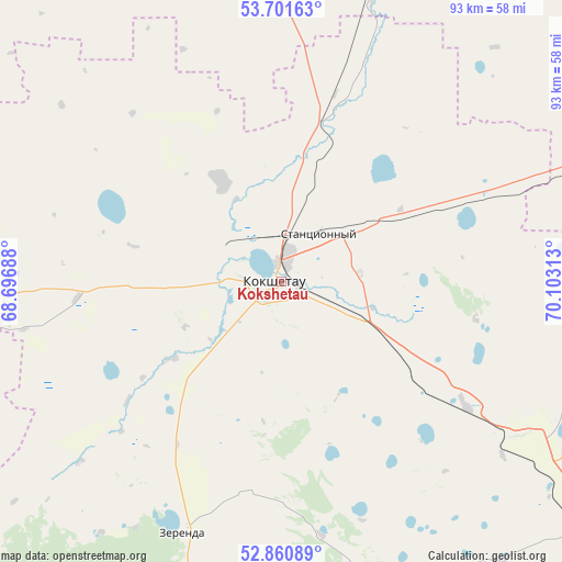
Kokshetau GPS coordinates[2]
53° 16' 59.988" North, 69° 24' 0" East
| Map corner | latitude | longitude |
|---|---|---|
| Upper-left | 53.70163°, | 68.69688° |
| Center: | 53.28333°, | 69.4° |
| Lower-right: | 52.86089°, | 70.10313° |
| Map W x H: | 93.5×93.5 km | = 58.1×58.1mi |
| max Lat: | 54.90596° ⇑7.4% North |
| Kokshetau: | 53.28333° |
| min Lat: | ⇓92.6% South 40.66338° |
| min Long | Kokshetau | max Long |
| 46.83361° | 69.4° | 84.87144° |
| W 43.7%⇐ | ⇒56.3% E |
Elevation
Elevation of Kokshetau is 234 m = 768 ft, and this is 122.5 m = 402 ft below average elevation for this country.
| Max E: |
1847 m = 6060 ft | 60.4% |
| Avg. | 356.5 m = 1170 ft | |
| Kokshetau | 234 m = 768 ft | |
Min E: |
-26 m = -85 ft | 39.6% |
See also: Kokshetau elevation on elevation.city.
Geographical zone
Kokshetau is located in North temperate zone (between Tropic of Cancer and the Arctic Circle). Distance of this North polar circle is 1476.6 km =917.5 mi to North.| Distance of | km | miles | from Kokshetau |
|---|---|---|---|
| North Pole | 4082.5 | 2536.7 | to North |
| Arctic Circle | 1476.6 | 917.5 | to North |
| Tropic Cancer | 3318.6 | 2062.1 | to South |
| Equator | 5924.6 | 3681.4 | to South |


Nearby cities:
15 places around Kokshetau: (largest is in red/bold)
• Akkol’
13.4 km =8.3 mi,  83°
83°
• Balkashino
95.6 km =59.4 mi,  207°
207°
• Birlestik
76.9 km =47.8 mi,  295°
295°
• Bishkul
167.3 km =104 mi,  353°
353°
• Būrabay
64.8 km =40.3 mi,  110°
110°
• Makinsk
99.4 km =61.8 mi,  136°
136°
• Sergeyevka
147.3 km =91.5 mi, 296°
• Shantobe
123.6 km =76.8 mi,  221°
221°
• Shchuchinsk
65.3 km =40.6 mi,  126°
126°
• Smirnovo
136.9 km =85.1 mi,  0°
0°
• Stepnyak
105.3 km =65.4 mi,  118°
118°
• Taiynsha
67.3 km =41.8 mi,  21°
21°
• Talshik
168.4 km =104.6 mi, 76°
• Volodarskoye
86.1 km =53.5 mi,  270°
270°
• Yavlenka
133.3 km =82.8 mi,  332°
332°
In other languages:
- In France: Kokchetaou
- In German: Kökschetau
- In Italian: Kökşetaw
- In Russian: Кокшетау
- In Chinese: 科克舍套
Sources, notices
• [Note1] Compared only with cities in Kazakhstan existing in our database
• [Src1] Map data: © OpenStreetMap contributors (CC-BY-SA)
• [Src2] Other city data from geonames.org with taken over terms of usage.
• [Src3] Geographical zone / Annual Mean Temperature by Robert A. Rohde @ Wikipedia
