Akkol’ geodata
Akkol’ (Aqmola) is a populated place; located in Kazakhstan in Asia/Almaty (GMT+5) time zone. With population of 16,773 people, there are 74 cities with bigger population in this country. Compared to other cities in Kazakhstan, 93.3% of cities are located further ↓South; 55.2% of cities are located further →East and 57.8% of cities have higher elevation than Akkol’. Note1


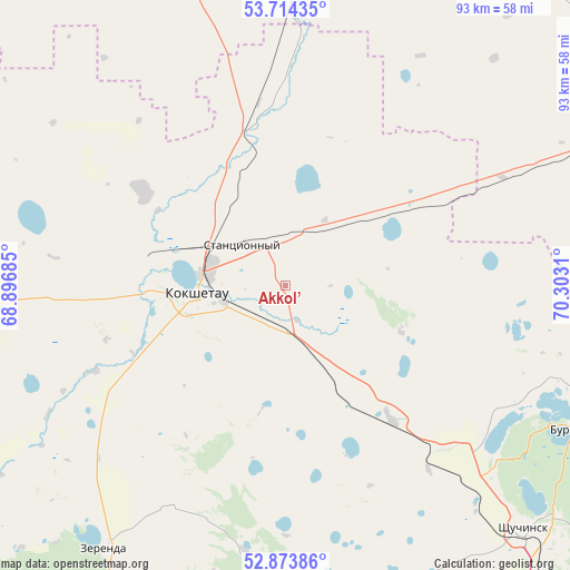
Akkol’ GPS coordinates[2]
53° 17' 46.212" North, 69° 35' 59.892" East
| Map corner | latitude | longitude |
|---|---|---|
| Upper-left | 53.71435°, | 68.89685° |
| Center: | 53.29617°, | 69.59997° |
| Lower-right: | 52.87386°, | 70.3031° |
| Map W x H: | 93.5×93.5 km | = 58.1×58.1mi |
| max Lat: | 54.90596° ⇑6.7% North |
| Akkol’: | 53.29617° |
| min Lat: | ⇓93.3% South 40.66338° |
| min Long | Akkol’ | max Long |
| 46.83361° | 69.59997° | 84.87144° |
| W 44.8%⇐ | ⇒55.2% E |
Elevation
Elevation of Akkol’ is 261 m = 856 ft, and this is 95.5 m = 313 ft below average elevation for this country.
| Max E: |
1847 m = 6060 ft | 57.8% |
| Avg. | 356.5 m = 1170 ft | |
| Akkol’ | 261 m = 856 ft | |
Min E: |
-26 m = -85 ft | 42.2% |
See also: Kazakhstan elevation on elevation.city.
Geographical zone
Akkol’ is located in North temperate zone (between Tropic of Cancer and the Arctic Circle). Distance of this North polar circle is 1475.2 km =916.6 mi to North.| Distance of | km | miles | from Akkol’ |
|---|---|---|---|
| North Pole | 4081.1 | 2535.9 | to North |
| Arctic Circle | 1475.2 | 916.6 | to North |
| Tropic Cancer | 3320.1 | 2063 | to South |
| Equator | 5926 | 3682.2 | to South |


Nearby cities:
15 places around Akkol’: (largest is in red/bold)
• Balkashino
103.6 km =64.4 mi,  213°
213°
• Birlestik
88.5 km =55 mi,  291°
291°
• Bishkul
167.9 km =104.3 mi,  348°
348°
• Būrabay
53.1 km =33 mi,  116°
116°
• Kokshetau
13.4 km =8.3 mi,  263°
263°
• Makinsk
91.9 km =57.1 mi,  143°
143°
• Sergeyevka
158.6 km =98.5 mi, 294°
• Shantobe
133.9 km =83.2 mi,  225°
225°
• Shchuchinsk
56.1 km =34.9 mi, 135°
• Smirnovo
136 km =84.5 mi,  355°
355°
• Stepnyak
94.5 km =58.7 mi, 122°
• Taiynsha
62.3 km =38.7 mi,  10°
10°
• Talshik
155.2 km =96.4 mi,  75°
75°
• Volodarskoye
99.4 km =61.8 mi,  269°
269°
• Yavlenka
138.7 km =86.2 mi,  327°
327°
Sources, notices
• [Note1] Compared only with cities in Kazakhstan existing in our database
• [Src1] Map data: © OpenStreetMap contributors (CC-BY-SA)
• [Src2] Other city data from geonames.org with taken over terms of usage.
• [Src3] Geographical zone / Annual Mean Temperature by Robert A. Rohde @ Wikipedia
