Birlestik geodata
Birlestik (Soltüstik Qazaqstan) is a populated place; located in Kazakhstan in Asia/Almaty (GMT+5) time zone. With population of 1,354 people, there are 257 cities with bigger population in this country. Compared to other cities in Kazakhstan, 94.8% of cities are located further ↓South; 63.3% of cities are located further →East and 60.4% of cities have higher elevation than Birlestik. Note1


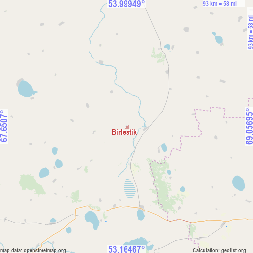
Birlestik GPS coordinates[2]
53° 35' 2.904" North, 68° 21' 13.752" East
| Map corner | latitude | longitude |
|---|---|---|
| Upper-left | 53.99949°, | 67.6507° |
| Center: | 53.58414°, | 68.35382° |
| Lower-right: | 53.16467°, | 69.05695° |
| Map W x H: | 92.8×92.8 km | = 57.7×57.7mi |
| max Lat: | 54.90596° ⇑5.2% North |
| Birlestik: | 53.58414° |
| min Lat: | ⇓94.8% South 40.66338° |
| min Long | Birlestik | max Long |
| 46.83361° | 68.35382° | 84.87144° |
| W 36.7%⇐ | ⇒63.3% E |
Elevation
Elevation of Birlestik is 234 m = 768 ft, and this is 122.5 m = 402 ft below average elevation for this country.
| Max E: |
1847 m = 6060 ft | 60.4% |
| Avg. | 356.5 m = 1170 ft | |
| Birlestik | 234 m = 768 ft | |
Min E: |
-26 m = -85 ft | 39.6% |
See also: Kazakhstan elevation on elevation.city.
Geographical zone
Birlestik is located in North temperate zone (between Tropic of Cancer and the Arctic Circle). Distance of this North polar circle is 1443.2 km =896.8 mi to North.| Distance of | km | miles | from Birlestik |
|---|---|---|---|
| North Pole | 4049.1 | 2516 | to North |
| Arctic Circle | 1443.2 | 896.8 | to North |
| Tropic Cancer | 3352.1 | 2082.9 | to South |
| Equator | 5958 | 3702.1 | to South |


Nearby cities:
15 places around Birlestik: (largest is in red/bold)
• Akkol’
88.5 km =55 mi,  111°
111°
• Balkashino
121.5 km =75.5 mi,  167°
167°
• Bishkul
141.3 km =87.8 mi,  20°
20°
• Būrabay
141.5 km =87.9 mi, 113°
• Kokshetau
76.9 km =47.8 mi,  115°
115°
• Novoishimskiy
113.5 km =70.5 mi,  247°
247°
• Petropavl
151.7 km =94.3 mi, 19°
• Sergeyevka
70.4 km =43.7 mi,  298°
298°
• Shantobe
126.3 km =78.5 mi,  185°
185°
• Shchuchinsk
141.7 km =88 mi, 120°
• Smirnovo
125 km =77.7 mi,  34°
34°
• Taiynsha
97.5 km =60.6 mi,  72°
72°
• Timiryazevo
124.2 km =77.2 mi,  278°
278°
• Volodarskoye
36.4 km =22.6 mi,  206°
206°
• Yavlenka
84.9 km =52.8 mi,  4°
4°
Sources, notices
• [Note1] Compared only with cities in Kazakhstan existing in our database
• [Src1] Map data: © OpenStreetMap contributors (CC-BY-SA)
• [Src2] Other city data from geonames.org with taken over terms of usage.
• [Src3] Geographical zone / Annual Mean Temperature by Robert A. Rohde @ Wikipedia
