Savannakhet geodata
Savannakhet (Savannahkhét) is a seat of a first-order administrative division; located in Laos in Asia/Vientiane (GMT+7) time zone. With population of 66,553 people, there are 3 cities with bigger population in this country. Compared to other cities in Laos, 69.2% of cities are located further ↑North; 65.4% of cities are located further ←West and 84.6% of cities have higher elevation than Savannakhet. Note1


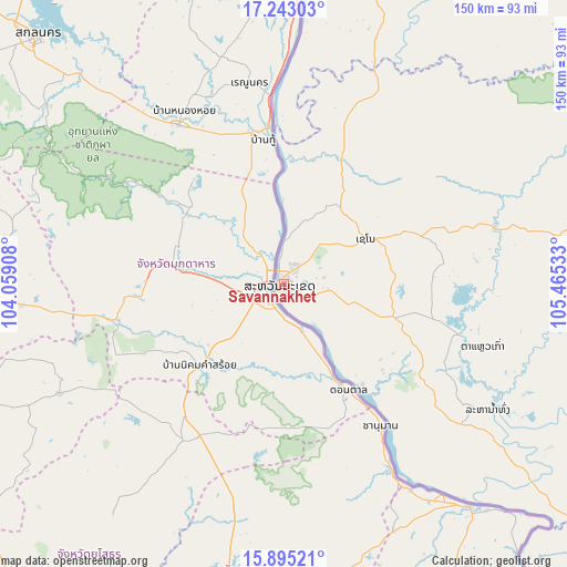
Savannakhet GPS coordinates[2]
16° 34' 13.08" North, 104° 45' 43.92" East
| Map corner | latitude | longitude |
|---|---|---|
| Upper-left | 17.24303°, | 104.05908° |
| Center: | 16.5703°, | 104.7622° |
| Lower-right: | 15.89521°, | 105.46533° |
| Map W x H: | 149.9×149.9 km | = 93.1×93.1mi |
| max Lat: | 21.6808° ⇑69.2% North |
| Savannakhet: | 16.5703° |
| min Lat: | ⇓30.8% South 14.11785° |
| min Long | Savannakhet | max Long |
| 100.4178° | 104.7622° | 107.26667° |
| W 65.4%⇐ | ⇒34.6% E |
Elevation
Elevation of Savannakhet is 141 m = 463 ft, and this is 332.6 m = 1091 ft below average elevation for this country.
| Max E: |
1722 m = 5650 ft | 84.6% |
| Avg. | 473.6 m = 1554 ft | |
| Savannakhet | 141 m = 463 ft | |
Min E: |
83 m = 272 ft | 15.4% |
See also: Savannakhet elevation on elevation.city.
Geographical zone
Savannakhet is located in North Torrid zone (between Equator and Tropic of Cancer). Distance of this Northern Tropic circle is 763.5 km =474.4 mi to North.| Distance of | km | miles | from Savannakhet |
|---|---|---|---|
| North Pole | 8164.6 | 5073.2 | to North |
| Arctic Circle | 5558.7 | 3454 | to North |
| Tropic Cancer | 763.5 | 474.4 | to North |
| Equator | 1842.4 | 1144.8 | to South |


Nearby cities:
15 places around Savannakhet: (largest is in red/bold)
• Ban Dônghén
57.3 km =35.6 mi,  75°
75°
• Ban Nahin
194.9 km =121.1 mi,  342°
342°
• Ban Thatèng
214.4 km =133.2 mi,  126°
126°
• Champasak
221.5 km =137.6 mi,  147°
147°
• Lamam
243.1 km =151.1 mi,  121°
121°
• Muang Hinboun
114.7 km =71.3 mi,  351°
351°
• Muang Khamkeut
184.1 km =114.4 mi,  358°
358°
• Muang Phin
134.5 km =83.6 mi,  91°
91°
• Pakkading
211.4 km =131.4 mi, 337°
• Pakse
195.7 km =121.6 mi, 145°
• Pakxan
234 km =145.4 mi,  330°
330°
• Pakxong
220.2 km =136.8 mi, 134°
• Phônthong
189.2 km =117.6 mi, 149°
• Salavan
200.7 km =124.7 mi, 118°
• Thakhèk
93.7 km =58.2 mi,  4°
4°
Sources, notices
• [Note1] Compared only with cities in Laos existing in our database
• [Src1] Map data: © OpenStreetMap contributors (CC-BY-SA)
• [Src2] Other city data from geonames.org with taken over terms of usage.
• [Src3] Geographical zone / Annual Mean Temperature by Robert A. Rohde @ Wikipedia
