Ban Nahin geodata
Ban Nahin (Bolikhamsai) is a populated place; located in Laos in Asia/Vientiane (GMT+7) time zone. With population of 3,466 people, there are 21 cities with bigger population in this country. Compared to other cities in Laos, 53.8% of cities are located further ↑North; 53.8% of cities are located further ←West and 73.1% of cities have higher elevation than Ban Nahin. Note1


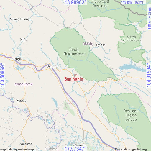
Ban Nahin GPS coordinates[2]
18° 14' 33.108" North, 104° 12' 46.116" East
| Map corner | latitude | longitude |
|---|---|---|
| Upper-left | 18.90902°, | 103.50969° |
| Center: | 18.24253°, | 104.21281° |
| Lower-right: | 17.57347°, | 104.91594° |
| Map W x H: | 148.5×148.5 km | = 92.3×92.3mi |
| max Lat: | 21.6808° ⇑53.8% North |
| Ban Nahin: | 18.24253° |
| min Lat: | ⇓46.2% South 14.11785° |
| min Long | Ban Nahin | max Long |
| 100.4178° | 104.21281° | 107.26667° |
| W 53.8%⇐ | ⇒46.2% E |
Elevation
Elevation of Ban Nahin is 162 m = 531 ft, and this is 311.6 m = 1022 ft below average elevation for this country.
| Max E: |
1722 m = 5650 ft | 73.1% |
| Avg. | 473.6 m = 1554 ft | |
| Ban Nahin | 162 m = 531 ft | |
Min E: |
83 m = 272 ft | 26.9% |
See also: Laos elevation on elevation.city.
Geographical zone
Ban Nahin is located in North Torrid zone (between Equator and Tropic of Cancer). Distance of this Northern Tropic circle is 577.5 km =358.8 mi to North.| Distance of | km | miles | from Ban Nahin |
|---|---|---|---|
| North Pole | 7978.7 | 4957.7 | to North |
| Arctic Circle | 5372.8 | 3338.5 | to North |
| Tropic Cancer | 577.5 | 358.8 | to North |
| Equator | 2028.4 | 1260.4 | to South |


Nearby cities:
15 places around Ban Nahin: (largest is in red/bold)
• Ban Dônghén
205.3 km =127.6 mi,  146°
146°
• Borikhan
62.4 km =38.8 mi,  304°
304°
• Huameung
215.2 km =133.7 mi,  350°
350°
• Muang Hinboun
83.4 km =51.8 mi, 150°
• Muang Khamkeut
54.8 km =34.1 mi,  91°
91°
• Muang Mok
77.3 km =48 mi,  343°
343°
• Muang Phôn-Hông
191.8 km =119.2 mi,  278°
278°
• Muang Phônsavan
171.9 km =106.8 mi,  321°
321°
• Pakkading
24.9 km =15.5 mi,  291°
291°
• Pakxan
60.6 km =37.7 mi, 286°
• Savannakhet
194.9 km =121.1 mi,  162°
162°
• Thakhèk
113.3 km =70.4 mi,  144°
144°
• Vangviang
200.8 km =124.8 mi, 292°
• Vientiane
173.2 km =107.6 mi,  259°
259°
• Xamtay
192 km =119.3 mi,  9°
9°
Sources, notices
• [Note1] Compared only with cities in Laos existing in our database
• [Src1] Map data: © OpenStreetMap contributors (CC-BY-SA)
• [Src2] Other city data from geonames.org with taken over terms of usage.
• [Src3] Geographical zone / Annual Mean Temperature by Robert A. Rohde @ Wikipedia
