Muang Khamkeut geodata
Muang Khamkeut (Bolikhamsai) is a seat of a second-order administrative division; located in Laos in Asia/Vientiane (GMT+7) time zone. In our database, there are 24 cities with bigger population. Compared to other cities in Laos, 55.8% of cities are located further ↑North; 63.5% of cities are located further ←West and 63.5% of cities have lower elevation than Muang Khamkeut. Note1


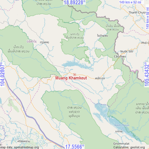
Muang Khamkeut GPS coordinates[2]
18° 13' 32.592" North, 104° 43' 52.284" East
| Map corner | latitude | longitude |
|---|---|---|
| Upper-left | 18.89228°, | 104.02807° |
| Center: | 18.22572°, | 104.73119° |
| Lower-right: | 17.5566°, | 105.43432° |
| Map W x H: | 148.5×148.5 km | = 92.3×92.3mi |
| max Lat: | 21.6808° ⇑55.8% North |
| Muang Khamkeut: | 18.22572° |
| min Lat: | ⇓44.2% South 14.11785° |
| min Long | Muang Khamkeut | max Long |
| 100.4178° | 104.73119° | 107.26667° |
| W 63.5%⇐ | ⇒36.5% E |
Elevation
Elevation of Muang Khamkeut is 430 m = 1411 ft, and this is 43.6 m = 143 ft below average elevation for this country.
| Max E: |
1722 m = 5650 ft | 36.5% |
| Avg. | 473.6 m = 1554 ft | |
| Muang Khamkeut | 430 m = 1411 ft | |
Min E: |
83 m = 272 ft | 63.5% |
See also: Laos elevation on elevation.city.
Geographical zone
Muang Khamkeut is located in North Torrid zone (between Equator and Tropic of Cancer). Distance of this Northern Tropic circle is 579.4 km =360 mi to North.| Distance of | km | miles | from Muang Khamkeut |
|---|---|---|---|
| North Pole | 7980.6 | 4958.9 | to North |
| Arctic Circle | 5374.7 | 3339.7 | to North |
| Tropic Cancer | 579.4 | 360 | to North |
| Equator | 2026.5 | 1259.2 | to South |


Nearby cities:
15 places around Muang Khamkeut: (largest is in red/bold)
• Ban Dônghén
179.1 km =111.3 mi,  160°
160°
• Ban Nahin
54.8 km =34.1 mi,  271°
271°
• Borikhan
112.4 km =69.8 mi,  289°
289°
• Huameung
232.6 km =144.5 mi,  336°
336°
• Muang Hinboun
71.8 km =44.6 mi,  190°
190°
• Muang Mok
107.8 km =67 mi,  314°
314°
• Muang Phin
232.8 km =144.7 mi,  143°
143°
• Muang Phônsavan
211.6 km =131.5 mi, 310°
• Pakkading
78.6 km =48.8 mi,  278°
278°
• Pakxan
114.5 km =71.1 mi, 279°
• Savannakhet
184.1 km =114.4 mi,  178°
178°
• Thakhèk
91.3 km =56.7 mi,  173°
173°
• Viengxay
238.8 km =148.4 mi,  350°
350°
• Vientiane
227.1 km =141.1 mi,  262°
262°
• Xamtay
192.5 km =119.6 mi, 353°
Sources, notices
• [Note1] Compared only with cities in Laos existing in our database
• [Src1] Map data: © OpenStreetMap contributors (CC-BY-SA)
• [Src2] Other city data from geonames.org with taken over terms of usage.
• [Src3] Geographical zone / Annual Mean Temperature by Robert A. Rohde @ Wikipedia
