Muang Hinboun geodata
Muang Hinboun (Khammouan) is a seat of a second-order administrative division; located in Laos in Asia/Vientiane (GMT+7) time zone. In our database, there are 24 cities with bigger population. Compared to other cities in Laos, 63.5% of cities are located further ↑North; 61.5% of cities are located further ←West and 78.8% of cities have higher elevation than Muang Hinboun. Note1


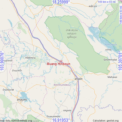
Muang Hinboun GPS coordinates[2]
17° 35' 27.6" North, 104° 36' 13.968" East
| Map corner | latitude | longitude |
|---|---|---|
| Upper-left | 18.25999°, | 103.90076° |
| Center: | 17.591°, | 104.60388° |
| Lower-right: | 16.91953°, | 105.30701° |
| Map W x H: | 149×149 km | = 92.6×92.6mi |
| max Lat: | 21.6808° ⇑63.5% North |
| Muang Hinboun: | 17.591° |
| min Lat: | ⇓36.5% South 14.11785° |
| min Long | Muang Hinboun | max Long |
| 100.4178° | 104.60388° | 107.26667° |
| W 61.5%⇐ | ⇒38.5% E |
Elevation
Elevation of Muang Hinboun is 153 m = 502 ft, and this is 320.6 m = 1052 ft below average elevation for this country.
| Max E: |
1722 m = 5650 ft | 78.8% |
| Avg. | 473.6 m = 1554 ft | |
| Muang Hinboun | 153 m = 502 ft | |
Min E: |
83 m = 272 ft | 21.2% |
See also: Laos elevation on elevation.city.
Geographical zone
Muang Hinboun is located in North Torrid zone (between Equator and Tropic of Cancer). Distance of this Northern Tropic circle is 650 km =403.9 mi to North.| Distance of | km | miles | from Muang Hinboun |
|---|---|---|---|
| North Pole | 8051.1 | 5002.7 | to North |
| Arctic Circle | 5445.2 | 3383.5 | to North |
| Tropic Cancer | 650 | 403.9 | to North |
| Equator | 1955.9 | 1215.3 | to South |


Nearby cities:
15 places around Muang Hinboun: (largest is in red/bold)
• Ban Dônghén
122.2 km =75.9 mi,  143°
143°
• Ban Nahin
83.4 km =51.8 mi,  330°
330°
• Borikhan
142.4 km =88.5 mi,  319°
319°
• Muang Khamkeut
71.8 km =44.6 mi,  10°
10°
• Muang Mok
159.7 km =99.2 mi,  336°
336°
• Muang Phin
191.3 km =118.9 mi,  127°
127°
• Muang Phôn-Hông
252.3 km =156.8 mi,  293°
293°
• Muang Phônsavan
254.7 km =158.3 mi, 324°
• Pakkading
104 km =64.6 mi, 321°
• Pakxan
133.9 km =83.2 mi,  311°
311°
• Savannakhet
114.7 km =71.3 mi,  171°
171°
• Thakhèk
31.3 km =19.4 mi, 129°
• Vangviang
271.6 km =168.8 mi,  303°
303°
• Vientiane
216.2 km =134.3 mi,  281°
281°
• Xamtay
261.9 km =162.7 mi,  358°
358°
Sources, notices
• [Note1] Compared only with cities in Laos existing in our database
• [Src1] Map data: © OpenStreetMap contributors (CC-BY-SA)
• [Src2] Other city data from geonames.org with taken over terms of usage.
• [Src3] Geographical zone / Annual Mean Temperature by Robert A. Rohde @ Wikipedia
