Tagiura geodata
Tagiura (Tripoli) is a populated place; located in Libya in Africa/Tripoli (GMT+2) time zone. With population of 100,000 people, there are 15 cities with bigger population in this country. Compared to other cities in Libya, 94.3% of cities are located further ↓South; 64.2% of cities are located further →East and 90.6% of cities have higher elevation than Tagiura. Note1


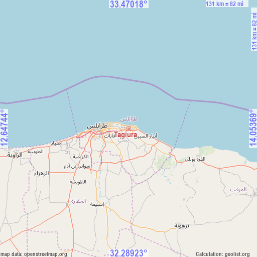
Tagiura GPS coordinates[2]
32° 52' 54.012" North, 13° 21' 2.016" East
| Map corner | latitude | longitude |
|---|---|---|
| Upper-left | 33.47018°, | 12.64744° |
| Center: | 32.88167°, | 13.35056° |
| Lower-right: | 32.28923°, | 14.05369° |
| Map W x H: | 131.3×131.3 km | = 81.6×81.6mi |
| max Lat: | 32.94699° ⇑5.7% North |
| Tagiura: | 32.88167° |
| min Lat: | ⇓94.3% South 24.1989° |
| min Long | Tagiura | max Long |
| 9.50072° | 13.35056° | 25.0866° |
| W 35.8%⇐ | ⇒64.2% E |
Elevation
Elevation of Tagiura is 6 m = 20 ft, and this is 226.2 m = 742 ft below average elevation for this country.
| Max E: |
704 m = 2310 ft | 90.6% |
| Avg. | 232.2 m = 762 ft | |
| Tagiura | 6 m = 20 ft | |
Min E: |
3 m = 10 ft | 9.4% |
See also: Tagiura elevation on elevation.city.
Geographical zone
Tagiura is located in North temperate zone (between Tropic of Cancer and the Arctic Circle). Distance of this Northern Tropic circle is 1050.2 km =652.6 mi to South.| Distance of | km | miles | from Tagiura |
|---|---|---|---|
| North Pole | 6351 | 3946.3 | to North |
| Arctic Circle | 3745.1 | 2327.1 | to North |
| Tropic Cancer | 1050.2 | 652.6 | to South |
| Equator | 3656.1 | 2271.8 | to South |


Nearby cities:
15 places around Tagiura: (largest is in red/bold)
• Al Ajaylat
92.1 km =57.2 mi,  261°
261°
• Al Khums
89.1 km =55.4 mi,  106°
106°
• Al ‘Azīzīyah
49.8 km =30.9 mi,  218°
218°
• Az Zāwīyah
59.8 km =37.2 mi, 256°
• Gharyan
84.7 km =52.6 mi,  201°
201°
• Masallātah
67.5 km =41.9 mi,  115°
115°
• Tarhuna
56.3 km =35 mi,  151°
151°
• Tripoli
15.3 km =9.5 mi,  272°
272°
• Yafran
119.3 km =74.1 mi, 220°
• Zalţan
138.7 km =86.2 mi, 273°
• Zawiya
59.9 km =37.2 mi, 256°
• Zliten
123 km =76.4 mi, 111°
• Zuwārah
118.5 km =73.6 mi, 272°
• Şabrātah
81.1 km =50.4 mi, 263°
• Şurmān
74.1 km =46 mi, 259°
Sources, notices
• [Note1] Compared only with cities in Libya existing in our database
• [Src1] Map data: © OpenStreetMap contributors (CC-BY-SA)
• [Src2] Other city data from geonames.org with taken over terms of usage.
• [Src3] Geographical zone / Annual Mean Temperature by Robert A. Rohde @ Wikipedia
