Tripoli geodata
Tripoli is a capital of a political entity; located in Libya in Africa/Tripoli (GMT+2) time zone. With population of 1,150,989 people, there are 0 cities with bigger population in this country. Compared to other cities in Libya, 96.2% of cities are located further ↓South; 66% of cities are located further →East and 88.7% of cities have higher elevation than Tripoli. Note1


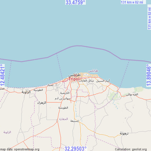
Tripoli GPS coordinates[2]
32° 53' 14.748" North, 13° 11' 14.388" East
| Map corner | latitude | longitude |
|---|---|---|
| Upper-left | 33.4759°, | 12.48421° |
| Center: | 32.88743°, | 13.18733° |
| Lower-right: | 32.29503°, | 13.89046° |
| Map W x H: | 131.3×131.3 km | = 81.6×81.6mi |
| max Lat: | 32.94699° ⇑3.8% North |
| Tripoli: | 32.88743° |
| min Lat: | ⇓96.2% South 24.1989° |
| min Long | Tripoli | max Long |
| 9.50072° | 13.18733° | 25.0866° |
| W 34%⇐ | ⇒66% E |
Elevation
Elevation of Tripoli is 7 m = 23 ft, and this is 225.2 m = 739 ft below average elevation for this country.
| Max E: |
704 m = 2310 ft | 88.7% |
| Avg. | 232.2 m = 762 ft | |
| Tripoli | 7 m = 23 ft | |
Min E: |
3 m = 10 ft | 11.3% |
See also: Tripoli elevation on elevation.city.
Geographical zone
Tripoli is located in North temperate zone (between Tropic of Cancer and the Arctic Circle). Distance of this Northern Tropic circle is 1050.8 km =652.9 mi to South.| Distance of | km | miles | from Tripoli |
|---|---|---|---|
| North Pole | 6350.3 | 3945.9 | to North |
| Arctic Circle | 3744.4 | 2326.7 | to North |
| Tropic Cancer | 1050.8 | 652.9 | to South |
| Equator | 3656.7 | 2272.2 | to South |


Nearby cities:
15 places around Tripoli: (largest is in red/bold)
• Al Ajaylat
77.2 km =48 mi,  259°
259°
• Al Khums
103.9 km =64.6 mi,  104°
104°
• Al ‘Azīzīyah
42.6 km =26.5 mi,  201°
201°
• Az Zāwīyah
45.3 km =28.1 mi,  251°
251°
• Gharyan
81.1 km =50.4 mi,  191°
191°
• Masallātah
81.7 km =50.8 mi,  111°
111°
• Tagiura
15.3 km =9.5 mi,  92°
92°
• Tarhuna
65.4 km =40.6 mi,  140°
140°
• Yafran
110.5 km =68.7 mi,  213°
213°
• Zalţan
123.4 km =76.7 mi,  273°
273°
• Zawiya
45.5 km =28.3 mi, 250°
• Zliten
137.5 km =85.4 mi, 109°
• Zuwārah
103.3 km =64.2 mi, 272°
• Şabrātah
66.1 km =41.1 mi, 260°
• Şurmān
59.3 km =36.8 mi, 255°
Sources, notices
• [Note1] Compared only with cities in Libya existing in our database
• [Src1] Map data: © OpenStreetMap contributors (CC-BY-SA)
• [Src2] Other city data from geonames.org with taken over terms of usage.
• [Src3] Geographical zone / Annual Mean Temperature by Robert A. Rohde @ Wikipedia
