Tarhuna geodata
Tarhuna (Al Marqab) is a populated place; located in Libya in Africa/Tripoli (GMT+2) time zone. With population of 210,697 people, there are 3 cities with bigger population in this country. Compared to other cities in Libya, 66% of cities are located further ↓South; 62.3% of cities are located further →East and 71.7% of cities have lower elevation than Tarhuna. Note1


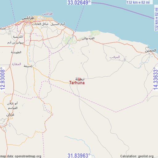
Tarhuna GPS coordinates[2]
32° 26' 6.036" North, 13° 37' 59.52" East
| Map corner | latitude | longitude |
|---|---|---|
| Upper-left | 33.02649°, | 12.93008° |
| Center: | 32.43501°, | 13.6332° |
| Lower-right: | 31.83963°, | 14.33633° |
| Map W x H: | 132×132 km | = 82×82mi |
| max Lat: | 32.94699° ⇑34% North |
| Tarhuna: | 32.43501° |
| min Lat: | ⇓66% South 24.1989° |
| min Long | Tarhuna | max Long |
| 9.50072° | 13.6332° | 25.0866° |
| W 37.7%⇐ | ⇒62.3% E |
Elevation
Elevation of Tarhuna is 391 m = 1283 ft, and this is 158.8 m = 521 ft above average elevation for this country.
| Max E: |
704 m = 2310 ft | 28.3% |
| Tarhuna | 391 m 1283 ft | |
| Avg. | 232.2 m = 762 ft | |
Min E: |
3 m = 10 ft | 71.7% |
See also: Tarhuna elevation on elevation.city.
Geographical zone
Tarhuna is located in North temperate zone (between Tropic of Cancer and the Arctic Circle). Distance of this Northern Tropic circle is 1000.5 km =621.7 mi to South.| Distance of | km | miles | from Tarhuna |
|---|---|---|---|
| North Pole | 6400.6 | 3977.1 | to North |
| Arctic Circle | 3794.7 | 2357.9 | to North |
| Tropic Cancer | 1000.5 | 621.7 | to South |
| Equator | 3606.4 | 2240.9 | to South |


Nearby cities:
15 places around Tarhuna: (largest is in red/bold)
• Al Ajaylat
123.1 km =76.5 mi,  286°
286°
• Al Khums
63.5 km =39.5 mi,  68°
68°
• Al ‘Azīzīyah
58.7 km =36.5 mi,  280°
280°
• Az Zāwīyah
92.1 km =57.2 mi, 292°
• Bani Walid
83.5 km =51.9 mi,  156°
156°
• Gharyan
64.6 km =40.1 mi,  243°
243°
• Masallātah
39.9 km =24.8 mi,  59°
59°
• Mizdah
125.5 km =78 mi,  209°
209°
• Tagiura
56.3 km =35 mi,  331°
331°
• Tripoli
65.4 km =40.6 mi,  320°
320°
• Yafran
111.8 km =69.5 mi,  248°
248°
• Zawiya
91.9 km =57.1 mi, 292°
• Zliten
87.9 km =54.6 mi,  87°
87°
• Şabrātah
114.4 km =71.1 mi, 290°
• Şurmān
105.7 km =65.7 mi, 289°
Sources, notices
• [Note1] Compared only with cities in Libya existing in our database
• [Src1] Map data: © OpenStreetMap contributors (CC-BY-SA)
• [Src2] Other city data from geonames.org with taken over terms of usage.
• [Src3] Geographical zone / Annual Mean Temperature by Robert A. Rohde @ Wikipedia
