Gharyan geodata
Gharyan (Jabal al Gharbi) is a seat of a first-order administrative division; located in Libya in Africa/Tripoli (GMT+2) time zone. With population of 85,219 people, there are 17 cities with bigger population in this country. Compared to other cities in Libya, 60.4% of cities are located further ↓South; 69.8% of cities are located further →East and 100% of cities have lower elevation than Gharyan. Note1


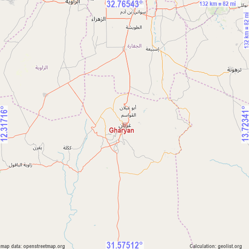
Gharyan GPS coordinates[2]
32° 10' 19.992" North, 13° 1' 13.008" East
| Map corner | latitude | longitude |
|---|---|---|
| Upper-left | 32.76543°, | 12.31716° |
| Center: | 32.17222°, | 13.02028° |
| Lower-right: | 31.57512°, | 13.72341° |
| Map W x H: | 132.4×132.4 km | = 82.3×82.3mi |
| max Lat: | 32.94699° ⇑39.6% North |
| Gharyan: | 32.17222° |
| min Lat: | ⇓60.4% South 24.1989° |
| min Long | Gharyan | max Long |
| 9.50072° | 13.02028° | 25.0866° |
| W 30.2%⇐ | ⇒69.8% E |
Elevation
Elevation of Gharyan is 704 m = 2310 ft, and this is 471.8 m = 1548 ft above average elevation for this country.
| Max E: |
704 m = 2310 ft | 0% |
| Gharyan | 704 m 2310 ft | |
| Avg. | 232.2 m = 762 ft | |
Min E: |
3 m = 10 ft | 100% |
See also: Gharyan elevation on elevation.city.
Geographical zone
Gharyan is located in North temperate zone (between Tropic of Cancer and the Arctic Circle). Distance of this Northern Tropic circle is 971.3 km =603.5 mi to South.| Distance of | km | miles | from Gharyan |
|---|---|---|---|
| North Pole | 6429.8 | 3995.3 | to North |
| Arctic Circle | 3824 | 2376.1 | to North |
| Tropic Cancer | 971.3 | 603.5 | to South |
| Equator | 3577.2 | 2222.8 | to South |


Nearby cities:
15 places around Gharyan: (largest is in red/bold)
• Al Ajaylat
88.8 km =55.2 mi,  317°
317°
• Al ‘Azīzīyah
40 km =24.9 mi,  359°
359°
• Az Zāwīyah
70.6 km =43.9 mi,  337°
337°
• Bani Walid
102.5 km =63.7 mi,  117°
117°
• Giado
96.5 km =60 mi,  255°
255°
• Masallātah
104.4 km =64.9 mi,  61°
61°
• Mizdah
80.4 km =50 mi,  182°
182°
• Tagiura
84.7 km =52.6 mi,  21°
21°
• Tarhuna
64.6 km =40.1 mi, 63°
• Tripoli
81.1 km =50.4 mi,  11°
11°
• Yafran
47.9 km =29.8 mi, 255°
• Zawiya
70.1 km =43.6 mi, 336°
• Zintan
77.1 km =47.9 mi,  249°
249°
• Şabrātah
85.2 km =52.9 mi, 324°
• Şurmān
77.4 km =48.1 mi,  327°
327°
Sources, notices
• [Note1] Compared only with cities in Libya existing in our database
• [Src1] Map data: © OpenStreetMap contributors (CC-BY-SA)
• [Src2] Other city data from geonames.org with taken over terms of usage.
• [Src3] Geographical zone / Annual Mean Temperature by Robert A. Rohde @ Wikipedia
