Masallātah geodata
Masallātah (Al Marqab) is a populated place; located in Libya in Africa/Tripoli (GMT+2) time zone. With population of 23,702 people, there are 35 cities with bigger population in this country. Compared to other cities in Libya, 75.5% of cities are located further ↓South; 56.6% of cities are located further →East and 52.8% of cities have lower elevation than Masallātah. Note1


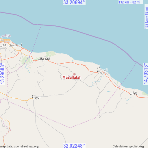
Masallātah GPS coordinates[2]
32° 37' 0.012" North, 14° 0' 0" East
| Map corner | latitude | longitude |
|---|---|---|
| Upper-left | 33.20694°, | 13.29688° |
| Center: | 32.61667°, | 14° |
| Lower-right: | 32.02248°, | 14.70313° |
| Map W x H: | 131.7×131.7 km | = 81.8×81.8mi |
| max Lat: | 32.94699° ⇑24.5% North |
| Masallātah: | 32.61667° |
| min Lat: | ⇓75.5% South 24.1989° |
| min Long | Masallātah | max Long |
| 9.50072° | 14° | 25.0866° |
| W 43.4%⇐ | ⇒56.6% E |
Elevation
Elevation of Masallātah is 236 m = 774 ft, and this is 3.8 m = 12 ft above average elevation for this country.
| Max E: |
704 m = 2310 ft | 47.2% |
| Masallātah | 236 m 774 ft | |
| Avg. | 232.2 m = 762 ft | |
Min E: |
3 m = 10 ft | 52.8% |
See also: Libya elevation on elevation.city.
Geographical zone
Masallātah is located in North temperate zone (between Tropic of Cancer and the Arctic Circle). Distance of this Northern Tropic circle is 1020.7 km =634.2 mi to South.| Distance of | km | miles | from Masallātah |
|---|---|---|---|
| North Pole | 6380.4 | 3964.6 | to North |
| Arctic Circle | 3774.5 | 2345.4 | to North |
| Tropic Cancer | 1020.7 | 634.2 | to South |
| Equator | 3626.6 | 2253.5 | to South |


Nearby cities:
15 places around Masallātah: (largest is in red/bold)
• Al Ajaylat
152.7 km =94.9 mi,  275°
275°
• Al Khums
24.8 km =15.4 mi,  81°
81°
• Al ‘Azīzīyah
92.5 km =57.5 mi,  264°
264°
• Az Zāwīyah
120.1 km =74.6 mi, 277°
• Bani Walid
96.9 km =60.2 mi,  180°
180°
• Gharyan
104.4 km =64.9 mi,  241°
241°
• Mişrātah
105.9 km =65.8 mi,  104°
104°
• Tagiura
67.5 km =41.9 mi,  295°
295°
• Tarhuna
39.9 km =24.8 mi, 239°
• Tripoli
81.7 km =50.8 mi,  291°
291°
• Yafran
151.3 km =94 mi,  246°
246°
• Zawiya
120 km =74.6 mi, 277°
• Zliten
55.8 km =34.7 mi,  107°
107°
• Şabrātah
142.8 km =88.7 mi, 277°
• Şurmān
134.6 km =83.6 mi, 276°
Sources, notices
• [Note1] Compared only with cities in Libya existing in our database
• [Src1] Map data: © OpenStreetMap contributors (CC-BY-SA)
• [Src2] Other city data from geonames.org with taken over terms of usage.
• [Src3] Geographical zone / Annual Mean Temperature by Robert A. Rohde @ Wikipedia
