Zliten geodata
Zliten (Mişrātah) is a populated place; located in Libya in Africa/Tripoli (GMT+2) time zone. With population of 109,972 people, there are 13 cities with bigger population in this country. Compared to other cities in Libya, 67.9% of cities are located further ↓South; 52.8% of cities are located further ←West and 83% of cities have higher elevation than Zliten. Note1


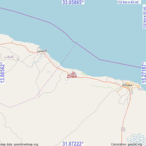
Zliten GPS coordinates[2]
32° 28' 2.604" North, 14° 34' 7.464" East
| Map corner | latitude | longitude |
|---|---|---|
| Upper-left | 33.05865°, | 13.86562° |
| Center: | 32.46739°, | 14.56874° |
| Lower-right: | 31.87222°, | 15.27187° |
| Map W x H: | 131.9×131.9 km | = 82×82mi |
| max Lat: | 32.94699° ⇑32.1% North |
| Zliten: | 32.46739° |
| min Lat: | ⇓67.9% South 24.1989° |
| min Long | Zliten | max Long |
| 9.50072° | 14.56874° | 25.0866° |
| W 52.8%⇐ | ⇒47.2% E |
Elevation
Elevation of Zliten is 9 m = 30 ft, and this is 223.2 m = 732 ft below average elevation for this country.
| Max E: |
704 m = 2310 ft | 83% |
| Avg. | 232.2 m = 762 ft | |
| Zliten | 9 m = 30 ft | |
Min E: |
3 m = 10 ft | 17% |
See also: Zliten elevation on elevation.city.
Geographical zone
Zliten is located in North temperate zone (between Tropic of Cancer and the Arctic Circle). Distance of this Northern Tropic circle is 1004.1 km =623.9 mi to South.| Distance of | km | miles | from Zliten |
|---|---|---|---|
| North Pole | 6397 | 3974.9 | to North |
| Arctic Circle | 3791.1 | 2355.7 | to North |
| Tropic Cancer | 1004.1 | 623.9 | to South |
| Equator | 3610 | 2243.1 | to South |


Nearby cities:
15 places around Zliten: (largest is in red/bold)
• Al Khums
35.1 km =21.8 mi,  305°
305°
• Al ‘Azīzīyah
145.6 km =90.5 mi,  272°
272°
• Az Zāwīyah
175.4 km =109 mi,  280°
280°
• Bani Walid
97.4 km =60.5 mi,  214°
214°
• Gharyan
149.2 km =92.7 mi,  257°
257°
• Masallātah
55.8 km =34.7 mi,  287°
287°
• Mizdah
187.4 km =116.4 mi,  232°
232°
• Mişrātah
50.2 km =31.2 mi,  101°
101°
• Tagiura
123 km =76.4 mi, 291°
• Tarhuna
87.9 km =54.6 mi, 267°
• Tripoli
137.5 km =85.4 mi, 289°
• Yafran
197 km =122.4 mi, 256°
• Zawiya
175.3 km =108.9 mi, 280°
• Şabrātah
198.1 km =123.1 mi, 280°
• Şurmān
189.8 km =117.9 mi, 279°
Sources, notices
• [Note1] Compared only with cities in Libya existing in our database
• [Src1] Map data: © OpenStreetMap contributors (CC-BY-SA)
• [Src2] Other city data from geonames.org with taken over terms of usage.
• [Src3] Geographical zone / Annual Mean Temperature by Robert A. Rohde @ Wikipedia
