Al Khums geodata
Al Khums (Al Marqab) is a seat of a first-order administrative division; located in Libya in Africa/Tripoli (GMT+2) time zone. With population of 201,943 people, there are 4 cities with bigger population in this country. Compared to other cities in Libya, 77.4% of cities are located further ↓South; 54.7% of cities are located further →East and 62.3% of cities have higher elevation than Al Khums. Note1


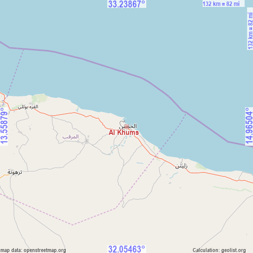
Al Khums GPS coordinates[2]
32° 38' 54.996" North, 14° 15' 42.876" East
| Map corner | latitude | longitude |
|---|---|---|
| Upper-left | 33.23867°, | 13.55879° |
| Center: | 32.64861°, | 14.26191° |
| Lower-right: | 32.05463°, | 14.96504° |
| Map W x H: | 131.7×131.7 km | = 81.8×81.8mi |
| max Lat: | 32.94699° ⇑22.6% North |
| Al Khums: | 32.64861° |
| min Lat: | ⇓77.4% South 24.1989° |
| min Long | Al Khums | max Long |
| 9.50072° | 14.26191° | 25.0866° |
| W 45.3%⇐ | ⇒54.7% E |
Elevation
Elevation of Al Khums is 27 m = 89 ft, and this is 205.2 m = 673 ft below average elevation for this country.
| Max E: |
704 m = 2310 ft | 62.3% |
| Avg. | 232.2 m = 762 ft | |
| Al Khums | 27 m = 89 ft | |
Min E: |
3 m = 10 ft | 37.7% |
See also: Al Khums elevation on elevation.city.
Geographical zone
Al Khums is located in North temperate zone (between Tropic of Cancer and the Arctic Circle). Distance of this Northern Tropic circle is 1024.3 km =636.5 mi to South.| Distance of | km | miles | from Al Khums |
|---|---|---|---|
| North Pole | 6376.9 | 3962.4 | to North |
| Arctic Circle | 3771 | 2343.2 | to North |
| Tropic Cancer | 1024.3 | 636.5 | to South |
| Equator | 3630.2 | 2255.7 | to South |


Nearby cities:
15 places around Al Khums: (largest is in red/bold)
• Al Ajaylat
176.8 km =109.9 mi,  273°
273°
• Al ‘Azīzīyah
117.3 km =72.9 mi,  263°
263°
• Az Zāwīyah
144.1 km =89.5 mi, 274°
• Bani Walid
103.8 km =64.5 mi,  194°
194°
• Gharyan
128 km =79.5 mi,  245°
245°
• Masallātah
24.8 km =15.4 mi, 261°
• Mişrātah
83.6 km =51.9 mi,  111°
111°
• Tagiura
89.1 km =55.4 mi,  286°
286°
• Tarhuna
63.5 km =39.5 mi, 248°
• Tripoli
103.9 km =64.6 mi,  284°
284°
• Yafran
175.3 km =108.9 mi, 248°
• Zawiya
144 km =89.5 mi, 274°
• Zliten
35.1 km =21.8 mi,  125°
125°
• Şabrātah
166.7 km =103.6 mi, 275°
• Şurmān
158.6 km =98.5 mi, 274°
Sources, notices
• [Note1] Compared only with cities in Libya existing in our database
• [Src1] Map data: © OpenStreetMap contributors (CC-BY-SA)
• [Src2] Other city data from geonames.org with taken over terms of usage.
• [Src3] Geographical zone / Annual Mean Temperature by Robert A. Rohde @ Wikipedia
