Marādah geodata
Marādah (Al Wāḩāt) is a populated place; located in Libya in Africa/Tripoli (GMT+2) time zone. With population of 2,229 people, there are 53 cities with bigger population in this country. Compared to other cities in Libya, 73.6% of cities are located further ↑North; 66% of cities are located further ←West and 60.4% of cities have higher elevation than Marādah. Note1


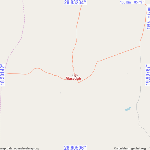
Marādah GPS coordinates[2]
29° 13' 13.944" North, 19° 12' 16.344" East
| Map corner | latitude | longitude |
|---|---|---|
| Upper-left | 29.83234°, | 18.50142° |
| Center: | 29.22054°, | 19.20454° |
| Lower-right: | 28.60506°, | 19.90767° |
| Map W x H: | 136.5×136.5 km | = 84.8×84.8mi |
| max Lat: | 32.94699° ⇑73.6% North |
| Marādah: | 29.22054° |
| min Lat: | ⇓26.4% South 24.1989° |
| min Long | Marādah | max Long |
| 9.50072° | 19.20454° | 25.0866° |
| W 66%⇐ | ⇒34% E |
Elevation
Elevation of Marādah is 39 m = 128 ft, and this is 193.2 m = 634 ft below average elevation for this country.
| Max E: |
704 m = 2310 ft | 60.4% |
| Avg. | 232.2 m = 762 ft | |
| Marādah | 39 m = 128 ft | |
Min E: |
3 m = 10 ft | 39.6% |
See also: Libya elevation on elevation.city.
Geographical zone
Marādah is located in North temperate zone (between Tropic of Cancer and the Arctic Circle). Distance of this Northern Tropic circle is 643.1 km =399.6 mi to South.| Distance of | km | miles | from Marādah |
|---|---|---|---|
| North Pole | 6758 | 4199.2 | to North |
| Arctic Circle | 4152.2 | 2580.1 | to North |
| Tropic Cancer | 643.1 | 399.6 | to South |
| Equator | 3249 | 2018.8 | to South |


Nearby cities:
14 places around Marādah: (largest is in red/bold)
• Ajdabiya
197 km =122.4 mi,  29°
29°
• Al Abyār
356 km =221.2 mi,  21°
21°
• Al Burayqah
136.6 km =84.9 mi, 15°
• Al Marj
395.5 km =245.8 mi, 23°
• Awjilah
202.6 km =125.9 mi,  93°
93°
• Az Zuwaytīnah
211.7 km =131.5 mi, 24°
• Benghazi
332.3 km =206.5 mi,  14°
14°
• Gialo
228.8 km =142.2 mi,  95°
95°
• Hūn
316.3 km =196.5 mi,  268°
268°
• Qaryat Sulūq
290.1 km =180.3 mi, 20°
• Qasr Abu Hadi
318.9 km =198.2 mi,  309°
309°
• Sirte
334.7 km =208 mi, 311°
• Tūkrah
391.1 km =243 mi, 19°
• Waddān
297.6 km =184.9 mi, 268°
Sources, notices
• [Note1] Compared only with cities in Libya existing in our database
• [Src1] Map data: © OpenStreetMap contributors (CC-BY-SA)
• [Src2] Other city data from geonames.org with taken over terms of usage.
• [Src3] Geographical zone / Annual Mean Temperature by Robert A. Rohde @ Wikipedia
