Ajdabiya geodata
Ajdabiya (Al Wāḩāt) is a seat of a first-order administrative division; located in Libya in Africa/Tripoli (GMT+2) time zone. With population of 134,358 people, there are 7 cities with bigger population in this country. Compared to other cities in Libya, 66% of cities are located further ↑North; 73.6% of cities are located further ←West and 100% of cities have higher elevation than Ajdabiya. Note1


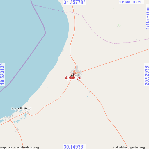
Ajdabiya GPS coordinates[2]
30° 45' 19.62" North, 20° 13' 34.5" East
| Map corner | latitude | longitude |
|---|---|---|
| Upper-left | 31.35778°, | 19.52313° |
| Center: | 30.75545°, | 20.22625° |
| Lower-right: | 30.14933°, | 20.92938° |
| Map W x H: | 134.4×134.4 km | = 83.5×83.5mi |
| max Lat: | 32.94699° ⇑66% North |
| Ajdabiya: | 30.75545° |
| min Lat: | ⇓34% South 24.1989° |
| min Long | Ajdabiya | max Long |
| 9.50072° | 20.22625° | 25.0866° |
| W 73.6%⇐ | ⇒26.4% E |
Elevation
Elevation of Ajdabiya is 3 m = 10 ft, and this is 229.2 m = 752 ft below average elevation for this country.
| Max E: |
704 m = 2310 ft | 100% |
| Avg. | 232.2 m = 762 ft | |
| Ajdabiya | 3 m = 10 ft | |
Min E: |
3 m = 10 ft | 0% |
See also: Ajdabiya elevation on elevation.city.
Geographical zone
Ajdabiya is located in North temperate zone (between Tropic of Cancer and the Arctic Circle). Distance of this Northern Tropic circle is 813.8 km =505.7 mi to South.| Distance of | km | miles | from Ajdabiya |
|---|---|---|---|
| North Pole | 6587.4 | 4093.2 | to North |
| Arctic Circle | 3981.5 | 2474 | to North |
| Tropic Cancer | 813.8 | 505.7 | to South |
| Equator | 3419.7 | 2124.9 | to South |


Nearby cities:
15 places around Ajdabiya: (largest is in red/bold)
• Al Abyār
163.3 km =101.5 mi,  12°
12°
• Al Bayḑā’
265.9 km =165.2 mi,  32°
32°
• Al Burayqah
73.5 km =45.7 mi,  238°
238°
• Al Marj
201.4 km =125.1 mi,  16°
16°
• Al Qubbah
292.9 km =182 mi,  40°
40°
• Awjilah
209.8 km =130.4 mi,  150°
150°
• Az Zuwaytīnah
24.1 km =15 mi,  335°
335°
• Benghazi
151.9 km =94.4 mi,  354°
354°
• Darnah
319.3 km =198.4 mi,  45°
45°
• Gialo
230.1 km =143 mi, 146°
• Marādah
197 km =122.4 mi,  209°
209°
• Qaryat Sulūq
101.5 km =63.1 mi,  1°
1°
• Qasr Abu Hadi
342 km =212.5 mi,  275°
275°
• Sirte
350.4 km =217.7 mi, 278°
• Tūkrah
200.6 km =124.6 mi, 9°
Sources, notices
• [Note1] Compared only with cities in Libya existing in our database
• [Src1] Map data: © OpenStreetMap contributors (CC-BY-SA)
• [Src2] Other city data from geonames.org with taken over terms of usage.
• [Src3] Geographical zone / Annual Mean Temperature by Robert A. Rohde @ Wikipedia
