Az Zuwaytīnah geodata
Az Zuwaytīnah (Al Wāḩāt) is a populated place; located in Libya in Africa/Tripoli (GMT+2) time zone. With population of 21,015 people, there are 37 cities with bigger population in this country. Compared to other cities in Libya, 64.2% of cities are located further ↑North; 71.7% of cities are located further ←West and 88.7% of cities have higher elevation than Az Zuwaytīnah. Note1


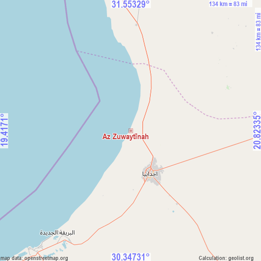
Az Zuwaytīnah GPS coordinates[2]
30° 57' 7.92" North, 20° 7' 12.792" East
| Map corner | latitude | longitude |
|---|---|---|
| Upper-left | 31.55329°, | 19.4171° |
| Center: | 30.9522°, | 20.12022° |
| Lower-right: | 30.34731°, | 20.82335° |
| Map W x H: | 134.1×134.1 km | = 83.3×83.3mi |
| max Lat: | 32.94699° ⇑64.2% North |
| Az Zuwaytīnah: | 30.9522° |
| min Lat: | ⇓35.8% South 24.1989° |
| min Long | Az Zuwaytīnah | max Long |
| 9.50072° | 20.12022° | 25.0866° |
| W 71.7%⇐ | ⇒28.3% E |
Elevation
Elevation of Az Zuwaytīnah is 7 m = 23 ft, and this is 225.2 m = 739 ft below average elevation for this country.
| Max E: |
704 m = 2310 ft | 88.7% |
| Avg. | 232.2 m = 762 ft | |
| Az Zuwaytīnah | 7 m = 23 ft | |
Min E: |
3 m = 10 ft | 11.3% |
See also: Libya elevation on elevation.city.
Geographical zone
Az Zuwaytīnah is located in North temperate zone (between Tropic of Cancer and the Arctic Circle). Distance of this Northern Tropic circle is 835.6 km =519.2 mi to South.| Distance of | km | miles | from Az Zuwaytīnah |
|---|---|---|---|
| North Pole | 6565.5 | 4079.6 | to North |
| Arctic Circle | 3959.6 | 2460.4 | to North |
| Tropic Cancer | 835.6 | 519.2 | to South |
| Equator | 3441.6 | 2138.5 | to South |


Nearby cities:
15 places around Az Zuwaytīnah: (largest is in red/bold)
• Ajdabiya
24.1 km =15 mi,  155°
155°
• Al Abyār
144.8 km =90 mi,  18°
18°
• Al Bayḑā’
253.7 km =157.6 mi,  37°
37°
• Al Burayqah
80.1 km =49.8 mi,  220°
220°
• Al Marj
183.9 km =114.3 mi, 21°
• Al Qubbah
283.5 km =176.2 mi, 44°
• Awjilah
233.8 km =145.3 mi,  151°
151°
• Benghazi
129.4 km =80.4 mi,  357°
357°
• Darnah
311.7 km =193.7 mi,  49°
49°
• Gialo
253.9 km =157.8 mi, 147°
• Marādah
211.7 km =131.5 mi,  204°
204°
• Qaryat Sulūq
80.6 km =50.1 mi,  8°
8°
• Qasr Abu Hadi
330.1 km =205.1 mi,  272°
272°
• Sirte
337.5 km =209.7 mi, 274°
• Tūkrah
181.2 km =112.6 mi, 13°
Sources, notices
• [Note1] Compared only with cities in Libya existing in our database
• [Src1] Map data: © OpenStreetMap contributors (CC-BY-SA)
• [Src2] Other city data from geonames.org with taken over terms of usage.
• [Src3] Geographical zone / Annual Mean Temperature by Robert A. Rohde @ Wikipedia
