Qasr Abu Hadi geodata
Qasr Abu Hadi (Surt) is a populated place; located in Libya in Africa/Tripoli (GMT+2) time zone. With population of 4,890 people, there are 47 cities with bigger population in this country. Compared to other cities in Libya, 62.3% of cities are located further ↑North; 64.2% of cities are located further ←West and 54.7% of cities have higher elevation than Qasr Abu Hadi. Note1


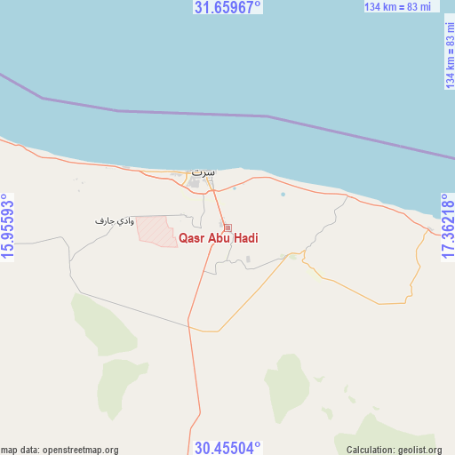
Qasr Abu Hadi GPS coordinates[2]
31° 3' 33.336" North, 16° 39' 32.58" East
| Map corner | latitude | longitude |
|---|---|---|
| Upper-left | 31.65967°, | 15.95593° |
| Center: | 31.05926°, | 16.65905° |
| Lower-right: | 30.45504°, | 17.36218° |
| Map W x H: | 133.9×133.9 km | = 83.2×83.2mi |
| max Lat: | 32.94699° ⇑62.3% North |
| Qasr Abu Hadi: | 31.05926° |
| min Lat: | ⇓37.7% South 24.1989° |
| min Long | Qasr Abu Hadi | max Long |
| 9.50072° | 16.65905° | 25.0866° |
| W 64.2%⇐ | ⇒35.8% E |
Elevation
Elevation of Qasr Abu Hadi is 49 m = 161 ft, and this is 183.2 m = 601 ft below average elevation for this country.
| Max E: |
704 m = 2310 ft | 54.7% |
| Avg. | 232.2 m = 762 ft | |
| Qasr Abu Hadi | 49 m = 161 ft | |
Min E: |
3 m = 10 ft | 45.3% |
See also: Libya elevation on elevation.city.
Geographical zone
Qasr Abu Hadi is located in North temperate zone (between Tropic of Cancer and the Arctic Circle). Distance of this Northern Tropic circle is 847.5 km =526.6 mi to South.| Distance of | km | miles | from Qasr Abu Hadi |
|---|---|---|---|
| North Pole | 6553.6 | 4072.2 | to North |
| Arctic Circle | 3947.7 | 2453 | to North |
| Tropic Cancer | 847.5 | 526.6 | to South |
| Equator | 3453.5 | 2145.9 | to South |


Nearby cities:
15 places around Qasr Abu Hadi: (largest is in red/bold)
• Ajdabiya
342 km =212.5 mi,  95°
95°
• Al Burayqah
287.9 km =178.9 mi, 104°
• Al Khums
287.2 km =178.5 mi,  307°
307°
• Az Zuwaytīnah
330.1 km =205.1 mi,  92°
92°
• Bani Walid
265.1 km =164.7 mi,  286°
286°
• Benghazi
343.6 km =213.5 mi,  70°
70°
• Hūn
225.5 km =140.1 mi,  197°
197°
• Marādah
318.9 km =198.2 mi,  129°
129°
• Masallātah
305.1 km =189.6 mi,  304°
304°
• Mişrātah
208.2 km =129.4 mi, 314°
• Qaryat Sulūq
347.8 km =216.1 mi,  78°
78°
• Sirte
17.9 km =11.1 mi,  338°
338°
• Tarhuna
324.4 km =201.6 mi, 298°
• Waddān
216.9 km =134.8 mi,  193°
193°
• Zliten
252.1 km =156.6 mi, 308°
Sources, notices
• [Note1] Compared only with cities in Libya existing in our database
• [Src1] Map data: © OpenStreetMap contributors (CC-BY-SA)
• [Src2] Other city data from geonames.org with taken over terms of usage.
• [Src3] Geographical zone / Annual Mean Temperature by Robert A. Rohde @ Wikipedia
