Tūkrah geodata
Tūkrah (Al Marj) is a populated place; located in Libya in Africa/Tripoli (GMT+2) time zone. With population of 23,164 people, there are 36 cities with bigger population in this country. Compared to other cities in Libya, 73.6% of cities are located further ↓South; 77.4% of cities are located further ←West and 75.5% of cities have higher elevation than Tūkrah. Note1


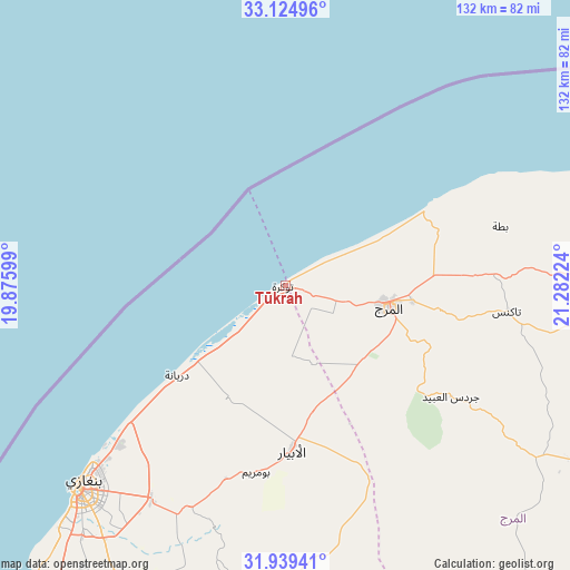
Tūkrah GPS coordinates[2]
32° 32' 2.904" North, 20° 34' 44.796" East
| Map corner | latitude | longitude |
|---|---|---|
| Upper-left | 33.12496°, | 19.87599° |
| Center: | 32.53414°, | 20.57911° |
| Lower-right: | 31.93941°, | 21.28224° |
| Map W x H: | 131.8×131.8 km | = 81.9×81.9mi |
| max Lat: | 32.94699° ⇑26.4% North |
| Tūkrah: | 32.53414° |
| min Lat: | ⇓73.6% South 24.1989° |
| min Long | Tūkrah | max Long |
| 9.50072° | 20.57911° | 25.0866° |
| W 77.4%⇐ | ⇒22.6% E |
Elevation
Elevation of Tūkrah is 16 m = 52 ft, and this is 216.2 m = 709 ft below average elevation for this country.
| Max E: |
704 m = 2310 ft | 75.5% |
| Avg. | 232.2 m = 762 ft | |
| Tūkrah | 16 m = 52 ft | |
Min E: |
3 m = 10 ft | 24.5% |
See also: Libya elevation on elevation.city.
Geographical zone
Tūkrah is located in North temperate zone (between Tropic of Cancer and the Arctic Circle). Distance of this Northern Tropic circle is 1011.5 km =628.5 mi to South.| Distance of | km | miles | from Tūkrah |
|---|---|---|---|
| North Pole | 6389.6 | 3970.3 | to North |
| Arctic Circle | 3783.7 | 2351.1 | to North |
| Tropic Cancer | 1011.5 | 628.5 | to South |
| Equator | 3617.5 | 2247.8 | to South |


Nearby cities:
14 places around Tūkrah: (largest is in red/bold)
• Ajdabiya
200.6 km =124.6 mi,  189°
189°
• Al Abyār
38.3 km =23.8 mi,  177°
177°
• Al Bayḑā’
113 km =70.2 mi,  77°
77°
• Al Burayqah
255.1 km =158.5 mi,  201°
201°
• Al Marj
23.9 km =14.9 mi,  101°
101°
• Al Qubbah
157.6 km =97.9 mi, 80°
• Awjilah
386.9 km =240.4 mi,  169°
169°
• Az Zuwaytīnah
181.2 km =112.6 mi, 193°
• Benghazi
66.9 km =41.6 mi,  225°
225°
• Darnah
194.4 km =120.8 mi, 82°
• Gialo
400.1 km =248.6 mi, 166°
• Marādah
391.1 km =243 mi, 199°
• Qaryat Sulūq
101.1 km =62.8 mi, 197°
• Tobruk
320.9 km =199.4 mi, 98°
Sources, notices
• [Note1] Compared only with cities in Libya existing in our database
• [Src1] Map data: © OpenStreetMap contributors (CC-BY-SA)
• [Src2] Other city data from geonames.org with taken over terms of usage.
• [Src3] Geographical zone / Annual Mean Temperature by Robert A. Rohde @ Wikipedia
