Al Marj geodata
Al Marj is a seat of a first-order administrative division; located in Libya in Africa/Tripoli (GMT+2) time zone. With population of 85,315 people, there are 16 cities with bigger population in this country. Compared to other cities in Libya, 69.8% of cities are located further ↓South; 81.1% of cities are located further ←West and 62.3% of cities have lower elevation than Al Marj. Note1


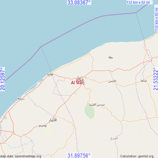
Al Marj GPS coordinates[2]
32° 29' 33.252" North, 20° 49' 44.724" East
| Map corner | latitude | longitude |
|---|---|---|
| Upper-left | 33.08367°, | 20.12597° |
| Center: | 32.49257°, | 20.82909° |
| Lower-right: | 31.89756°, | 21.53222° |
| Map W x H: | 131.9×131.9 km | = 82×82mi |
| max Lat: | 32.94699° ⇑30.2% North |
| Al Marj: | 32.49257° |
| min Lat: | ⇓69.8% South 24.1989° |
| min Long | Al Marj | max Long |
| 9.50072° | 20.82909° | 25.0866° |
| W 81.1%⇐ | ⇒18.9% E |
Elevation
Elevation of Al Marj is 334 m = 1096 ft, and this is 101.8 m = 334 ft above average elevation for this country.
| Max E: |
704 m = 2310 ft | 37.7% |
| Al Marj | 334 m 1096 ft | |
| Avg. | 232.2 m = 762 ft | |
Min E: |
3 m = 10 ft | 62.3% |
See also: Al Marj elevation on elevation.city.
Geographical zone
Al Marj is located in North temperate zone (between Tropic of Cancer and the Arctic Circle). Distance of this Northern Tropic circle is 1006.9 km =625.7 mi to South.| Distance of | km | miles | from Al Marj |
|---|---|---|---|
| North Pole | 6394.2 | 3973.2 | to North |
| Arctic Circle | 3788.3 | 2353.9 | to North |
| Tropic Cancer | 1006.9 | 625.7 | to South |
| Equator | 3612.8 | 2244.9 | to South |


Nearby cities:
14 places around Al Marj: (largest is in red/bold)
• Ajdabiya
201.4 km =125.1 mi,  196°
196°
• Al Abyār
40.1 km =24.9 mi,  212°
212°
• Al Bayḑā’
91.8 km =57 mi,  70°
70°
• Al Burayqah
260.7 km =162 mi, 207°
• Al Qubbah
135.4 km =84.1 mi,  77°
77°
• Awjilah
378.9 km =235.4 mi,  173°
173°
• Az Zuwaytīnah
183.9 km =114.3 mi, 201°
• Benghazi
82.9 km =51.5 mi,  239°
239°
• Darnah
172 km =106.9 mi, 79°
• Gialo
390.7 km =242.8 mi, 169°
• Marādah
395.5 km =245.8 mi, 203°
• Qaryat Sulūq
106.6 km =66.2 mi, 210°
• Tobruk
297.1 km =184.6 mi,  98°
98°
• Tūkrah
23.9 km =14.9 mi,  281°
281°
Sources, notices
• [Note1] Compared only with cities in Libya existing in our database
• [Src1] Map data: © OpenStreetMap contributors (CC-BY-SA)
• [Src2] Other city data from geonames.org with taken over terms of usage.
• [Src3] Geographical zone / Annual Mean Temperature by Robert A. Rohde @ Wikipedia
